
Topografische Karte Scuol
Interaktive Karte
Klicken Sie auf die Karte, um die Höhe anzuzeigen.
Über diese Karte
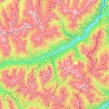
Name: Topografische Karte Scuol, Höhe, Relief.
Durchschnittliche Höhe: 2.240 m
Minimale Höhe: 1.020 m
Maximale Höhe: 3.350 m
The God da Tamangur ("the forest back there") is the highest continuous stone pine (pinus cembra) forest in Europe, right at the furthest end of the Val S-charl, south of Scuol. The forest nature reserve covers an area of about 84 ha (210 acres) at up to 2,400 m (7,900 ft) in elevation. Due to the altitude and weather, the trees grow very slowly and may live up to 700 years.
Andere topografische Karten
Klicken Sie auf eine Karte, um ihre Topografie, ihre Höhe und ihr Relief anzuzeigen.
Minschuns
Switzerland > Grisons > Region Engiadina Bassa/Val Müstair > Val Müstair
Minschuns, Val Müstair, Region Engiadina Bassa/Val Müstair, Grisons, 7532, Switzerland
Durchschnittliche Höhe: 2.272 m
Vulpera
Switzerland > Grisons > Region Engiadina Bassa/Val Müstair > Scuol
Vulpera, Scuol, Region Engiadina Bassa/Val Müstair, Grisons, 7550, Switzerland
Durchschnittliche Höhe: 1.500 m
Flüelapass
Switzerland > Grisons > Region Engiadina Bassa/Val Müstair > Zernez
Flüelapass, Zernez, Region Engiadina Bassa/Val Müstair, Grisons, Switzerland
Durchschnittliche Höhe: 2.568 m
Tschierv
Switzerland > Grisons > Region Engiadina Bassa/Val Müstair > Val Müstair
Tschierv, Val Müstair, Region Engiadina Bassa/Val Müstair, Grisons, 7532, Switzerland
Durchschnittliche Höhe: 2.023 m
Zernez
Switzerland > Grisons > Region Engiadina Bassa/Val Müstair
Zernez, Region Engiadina Bassa/Val Müstair, Grisons, Switzerland
Durchschnittliche Höhe: 2.297 m