
Topografische Karte Aketajawe Lolobata National Park
Interaktive Karte
Klicken Sie auf die Karte, um die Höhe anzuzeigen.
Aketajawe Lolobata National Park
Threats to the national park are posed by illegal logging and mining. Between 1990 and 2003 forests declined in North Maluku from 86% to just under 70%, with much of it occurring in the lowlands (below 400m). As a result, species with large amounts of their range at low elevations were most strongly affected.
Über diese Karte
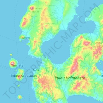
Name: Topografische Karte Aketajawe Lolobata National Park, Höhe, Relief.
Durchschnittliche Höhe: 161 m
Minimale Höhe: 0 m
Maximale Höhe: 1.688 m