
Topografische Karte Olivos
Interaktive Karte
Klicken Sie auf die Karte, um die Höhe anzuzeigen.
Über diese Karte
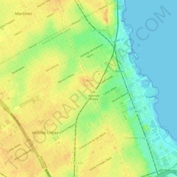
Name: Topografische Karte Olivos, Höhe, Relief.
Durchschnittliche Höhe: 17 m
Minimale Höhe: -2 m
Maximale Höhe: 31 m
Olivos is located on the western bank of the Río de la Plata, the world's widest river. The river is approximately 50 km (31 mi) wide at Olivos, and as such, Uruguay is not visible from ground level. However, Olivos (and this entire region of the Rio) do not have sandy beaches; the shoreline is relatively rocky. Comparable shorelines include those of the Great Lakes in North America. The city's topography is relatively flat. However, there are some ridges by the river towards the north, in the La Lucila neighbourhood.
Andere topografische Karten
Klicken Sie auf eine Karte, um ihre Topografie, ihre Höhe und ihr Relief anzuzeigen.
Munro
Argentina > Buenos Aires > Vicente López
Munro, Vicente López, Partido de Vicente López, Buenos Aires, Argentina
Durchschnittliche Höhe: 26 m
Vicente López
Argentina > Buenos Aires > Vicente López
Vicente López, Partido de Vicente López, Buenos Aires, Argentina
Durchschnittliche Höhe: 20 m