
Topografische Karte Morazán
Interaktive Karte
Klicken Sie auf die Karte, um die Höhe anzuzeigen.
Über diese Karte
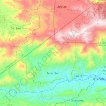
Name: Topografische Karte Morazán, Höhe, Relief.
Ort: Morazán, El Progreso, Guatemala (14.87425 -90.32144 15.10547 -90.00866)
Durchschnittliche Höhe: 1.151 m
Minimale Höhe: 264 m
Maximale Höhe: 2.626 m
Andere topografische Karten
Klicken Sie auf eine Karte, um ihre Topografie, ihre Höhe und ihr Relief anzuzeigen.
San Antonio La Paz
San Antonio La Paz, El Progreso, Guatemala
Durchschnittliche Höhe: 1.141 m
Guastatoya
Guatemala > El Progreso > Guastatoya
Guastatoya, El Progreso, Guatemala
Durchschnittliche Höhe: 908 m
San Agustín Acasaguastlán
San Agustín Acasaguastlán, El Progreso, Guatemala
Durchschnittliche Höhe: 1.312 m
Guastatoya
Guatemala > El Progreso > Guastatoya
Guastatoya, El Progreso, Guatemala
Durchschnittliche Höhe: 780 m
Morazán
Guatemala > El Progreso > Morazán
Morazán, El Progreso, Guatemala
Durchschnittliche Höhe: 538 m