
Spenden
Rüste dich für dein nächstes Abenteuer:
Als Amazon-Partner verdient diese Website an qualifizierten Käufen, ohne zusätzliche Kosten für Sie.
Topografische Karte Slinger
Klicken Sie auf die Karte, um die Höhe anzuzeigen.
Spenden
Rüste dich für dein nächstes Abenteuer:
Als Amazon-Partner verdient diese Website an qualifizierten Käufen, ohne zusätzliche Kosten für Sie.
Über diese Karte
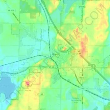
Name: Topografische Karte Slinger, Höhe, Relief.
Ort: Slinger, Washington County, Wisconsin, United States (43.30110 -88.32591 43.36419 -88.22485)
Durchschnittliche Höhe: 331 m
Minimale Höhe: 302 m
Maximale Höhe: 395 m
Spenden
Rüste dich für dein nächstes Abenteuer:
Als Amazon-Partner verdient diese Website an qualifizierten Käufen, ohne zusätzliche Kosten für Sie.
Andere topografische Karten
Klicken Sie auf eine Karte, um ihre Topografie, ihre Höhe und ihr Relief anzuzeigen.
Milwaukee River Floodplain Forest State Natural Area
United States > Wisconsin > Washington County
Durchschnittliche Höhe: 291 m
Allenton
United States > Wisconsin > Washington County
Allenton is located at latitude 43.421 and longitude -88.341. The elevation is 958 feet. Allenton has an area of 1.446 square miles (3.75 km2), all of it land. The Rock River cuts through the town.
Durchschnittliche Höhe: 313 m