
Topografische Karte Brookings
Interaktive Karte
Klicken Sie auf die Karte, um die Höhe anzuzeigen.
Über diese Karte
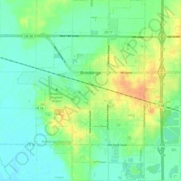
Name: Topografische Karte Brookings, Höhe, Relief.
Durchschnittliche Höhe: 495 m
Minimale Höhe: 482 m
Maximale Höhe: 517 m
Andere topografische Karten
Klicken Sie auf eine Karte, um ihre Topografie, ihre Höhe und ihr Relief anzuzeigen.
Aurora Township
United States > South Dakota > Brookings County
Aurora Township, Brookings County, South Dakota, 57002, United States
Durchschnittliche Höhe: 503 m
Brooking Municipal Utilitys
United States > South Dakota > Brookings County > Brookings
Brooking Municipal Utilitys, Brookings, Brookings Township, Brookings County, South Dakota, United States
Durchschnittliche Höhe: 492 m
Bruce
United States > South Dakota > Brookings County > Bruce
Bruce, Brookings County, South Dakota, United States
Durchschnittliche Höhe: 502 m