
Topografische Karte Maple Falls
Interaktive Karte
Klicken Sie auf die Karte, um die Höhe anzuzeigen.
Über diese Karte
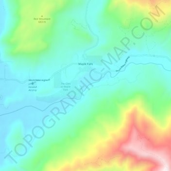
Name: Topografische Karte Maple Falls, Höhe, Relief.
Ort: Maple Falls, Whatcom County, Washington, United States (48.89188 -122.14660 48.93709 -122.03118)
Durchschnittliche Höhe: 442 m
Minimale Höhe: 122 m
Maximale Höhe: 1.419 m
Andere topografische Karten
Klicken Sie auf eine Karte, um ihre Topografie, ihre Höhe und ihr Relief anzuzeigen.
Ferndale
United States > Washington > Whatcom County
Ferndale, Whatcom County, Washington, United States
Durchschnittliche Höhe: 29 m
Skagit River
United States > Washington > Whatcom County
Skagit River, Whatcom County, Washington, United States
Durchschnittliche Höhe: 1.391 m
Kloke Peak (Hayden Peak)
United States > Washington > Whatcom County
Kloke Peak (Hayden Peak), Whatcom County, Washington, United States
Durchschnittliche Höhe: 1.544 m
Mount Baker
United States > Washington > Whatcom County
Mount Baker, Whatcom County, Washington, United States
Durchschnittliche Höhe: 2.698 m