
Topografische Karte Hannington
Klicken Sie auf die Karte, um die Höhe anzuzeigen.
Über diese Karte
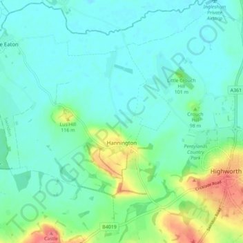
Name: Topografische Karte Hannington, Höhe, Relief.
Ort: Hannington, Swindon, England, United Kingdom (51.61634 -1.77281 51.66984 -1.71879)
Durchschnittliche Höhe: 88 m
Minimale Höhe: 71 m
Maximale Höhe: 142 m
Andere topografische Karten
Klicken Sie auf eine Karte, um ihre Topografie, ihre Höhe und ihr Relief anzuzeigen.
Swindon
United Kingdom > England > Swindon
Swindon has an oceanic climate (Cfb in the Köppen climate classification), like the vast majority of the British Isles, with cool winters and warm summers. The nearest official weather station is RAF Lyneham, about 10 miles (16 km) west southwest of Swindon town centre. The weather station's elevation is 145…
Durchschnittliche Höhe: 108 m