
Topografische Karte Spile
Interaktive Karte
Klicken Sie auf die Karte, um die Höhe anzuzeigen.
Über diese Karte
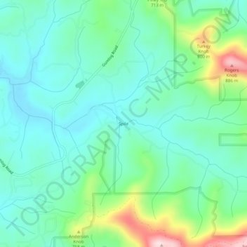
Name: Topografische Karte Spile, Höhe, Relief.
Ort: Spile, Union County, Georgia, United States (34.91453 -83.99963 34.95453 -83.95963)
Durchschnittliche Höhe: 646 m
Minimale Höhe: 561 m
Maximale Höhe: 898 m
Andere topografische Karten
Klicken Sie auf eine Karte, um ihre Topografie, ihre Höhe und ihr Relief anzuzeigen.
Blairsville
United States > Georgia > Union County
Blairsville, Union County, Georgia, United States
Durchschnittliche Höhe: 587 m
Suches
United States > Georgia > Union County
Suches, Union County, Georgia, United States
Durchschnittliche Höhe: 871 m
Vogel State Park
United States > Georgia > Union County
Vogel State Park, Union County, Georgia, United States
Durchschnittliche Höhe: 838 m
Hawk Mountain
United States > Georgia > Union County
Hawk Mountain, Union County, Georgia, United States
Durchschnittliche Höhe: 912 m
Bethlehem
United States > Georgia > Union County
Bethlehem, Union County, Georgia, United States
Durchschnittliche Höhe: 582 m
Fort Mountain
United States > Georgia > Union County
Fort Mountain, Union County, Georgia, United States
Durchschnittliche Höhe: 679 m
Blue Rock
United States > Georgia > Union County
Blue Rock, Union County, Georgia, United States
Durchschnittliche Höhe: 780 m