

Topografische Karte Zihuatanejo
Klicken Sie auf die Karte, um die Höhe anzuzeigen.
Zihuatanejo
The town of Zihuatanejo is the seat of the municipality of Zihuatanejo de Azueta and as such is the governmental authority for approximately 416 communities, with a total population of 104,609 as of 2005, and an area of 1,921.5 km2 (741.9 sq mi). There are small indigenous communities in the municipality which speak Nahuatl and Tlapaneco. Population increase for the period of 1995-2000 was 1.85 percent, with a population density of just under fifty people per square km. The greatest population increase was seen in the 1980s when the municipality jumped from 25,751 to 63,366 residents. The municipality borders the municipalities of Coyuca de Catalán, Coahuayutla de José María Izazaga, Petatlán and La Unión de Isidoro Montes de Oca, as well as the Pacific Ocean. Altitude varies from between 0 and 1,000 meters (0 and 3,281 feet) above sea level. Much of the municipality (70%) is rugged terrain with the rest being semi-flat or flat. Major peaks here are the Sierra de la Cuchara and the Cumbre de la Peatada. Major rivers here include the Verde and the Ixtapa. There are also a number of small streams such as the Real, Pantla, Zapote, and Lagunillas.
Über diese Karte
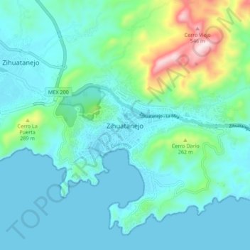
Name: Topografische Karte Zihuatanejo, Höhe, Relief.
Durchschnittliche Höhe: 104 m
Minimale Höhe: 0 m
Maximale Höhe: 588 m