
Topografische Karte East Quincy
Interaktive Karte
Klicken Sie auf die Karte, um die Höhe anzuzeigen.
Über diese Karte
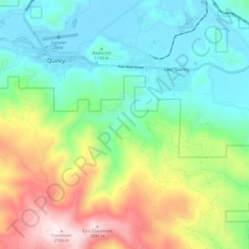
Name: Topografische Karte East Quincy, Höhe, Relief.
Ort: East Quincy, Plumas County, California, United States (39.87772 -120.95454 39.95551 -120.86824)
Durchschnittliche Höhe: 1.389 m
Minimale Höhe: 1.035 m
Maximale Höhe: 2.132 m
East-Quincy has a Mediterranean climate (Köppen Csb) though its inland location and altitude makes it more continental and wetter than usual for this type, with very heavy snowfalls sometimes occurring in winter – the record being 133 inches (337.8 cm) in the very wet January 1916.[5][6] Although summer days are hot and only 1.4 days per winter fail to top 32 °F (0 °C), nights can be very cold and frosts occur on 179 days per year and have been recorded even in July.
Andere topografische Karten
Klicken Sie auf eine Karte, um ihre Topografie, ihre Höhe und ihr Relief anzuzeigen.
Quincy
United States > California > Plumas County
Quincy, Plumas County, California, 95971, United States
Durchschnittliche Höhe: 1.274 m
Ski Hill
United States > California > Plumas County
Ski Hill, Plumas County, California, 96020, United States
Durchschnittliche Höhe: 1.609 m
La Porte
United States > California > Plumas County
La Porte, Plumas County, California, United States
Durchschnittliche Höhe: 1.524 m
Indian Falls
United States > California > Plumas County
Indian Falls, Plumas County, California, United States
Durchschnittliche Höhe: 1.243 m