
Topografische Karte Mount Conner
Interaktive Karte
Klicken Sie auf die Karte, um die Höhe anzuzeigen.
Über diese Karte
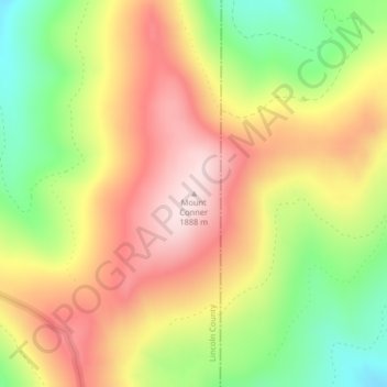
Name: Topografische Karte Mount Conner, Höhe, Relief.
Ort: Mount Conner, Lincoln County, Montana, United States (48.32797 -114.85158 48.32807 -114.85148)
Durchschnittliche Höhe: 1.698 m
Minimale Höhe: 1.498 m
Maximale Höhe: 1.877 m
Andere topografische Karten
Klicken Sie auf eine Karte, um ihre Topografie, ihre Höhe und ihr Relief anzuzeigen.
Frank Lake
United States > Montana > Lincoln County
Frank Lake, Lincoln County, Montana, United States
Durchschnittliche Höhe: 999 m
Tobacco
United States > Montana > Lincoln County
Tobacco, Lincoln County, Montana, 59917, United States
Durchschnittliche Höhe: 873 m
Trego
United States > Montana > Lincoln County
Trego, Lincoln County, Montana, 59934, United States
Durchschnittliche Höhe: 974 m
Wolf Creek
United States > Montana > Lincoln County
Wolf Creek, Lincoln County, Montana, United States
Durchschnittliche Höhe: 1.225 m
Eureka
United States > Montana > Lincoln County
Eureka, Lincoln County, Montana, United States
Durchschnittliche Höhe: 832 m