
Topografische Karte Vilamaior
Interaktive Karte
Klicken Sie auf die Karte, um die Höhe anzuzeigen.
Über diese Karte
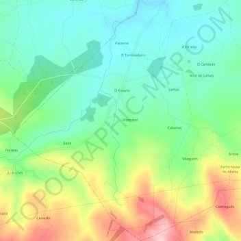
Name: Topografische Karte Vilamaior, Höhe, Relief.
Ort: Vilamaior, Sarria, Lugo, Galicia, España (42.70672 -7.54410 42.75043 -7.49976)
Durchschnittliche Höhe: 623 m
Minimale Höhe: 548 m
Maximale Höhe: 766 m
Andere topografische Karten
Klicken Sie auf eine Karte, um ihre Topografie, ihre Höhe und ihr Relief anzuzeigen.
O Peruscallo
España > Galicia > Sarria > Sarria
O Peruscallo, Belante, Sarria, Lugo, Galicia, 27612, España
Durchschnittliche Höhe: 648 m
Santo André de Paradela
España > Galicia > Sarria > Sarria
Santo André de Paradela, Sarria, Lugo, Galicia, España
Durchschnittliche Höhe: 578 m
San Vicenzo
España > Galicia > Sarria > Sarria > San Vicenzo
San Vicenzo, Maside, Sarria, Galicia, 27619, España
Durchschnittliche Höhe: 520 m