
Spenden
Rüste dich für dein nächstes Abenteuer:
Als Amazon-Partner verdient diese Website an qualifizierten Käufen, ohne zusätzliche Kosten für Sie.
Topografische Karte Double Horn
Klicken Sie auf die Karte, um die Höhe anzuzeigen.
Spenden
Rüste dich für dein nächstes Abenteuer:
Als Amazon-Partner verdient diese Website an qualifizierten Käufen, ohne zusätzliche Kosten für Sie.
Double Horn
The original settlement of Double Horn was established near the headwaters of Double Horn Creek in 1855, with the creek and town named for an incident where a pioneer found the remains of two bucks with interlocked antlers. It had a post office from 1857 to 1911, a school (the Double Horn School), a cotton gin, and two churches. In 1884, the population was 50; by 1896, this population had halved, and by 1936, only the school remained marked on state road maps. Double Horn had completely disappeared from maps as a separate community by the second half of the 20th century. This location is close to a lightly populated ranching area marked on modern topographic maps as Shovel Mountain.
Spenden
Rüste dich für dein nächstes Abenteuer:
Als Amazon-Partner verdient diese Website an qualifizierten Käufen, ohne zusätzliche Kosten für Sie.
Über diese Karte
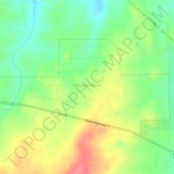
Name: Topografische Karte Double Horn, Höhe, Relief.
Ort: Double Horn, Burnet County, Texas, United States (30.48668 -98.24417 30.50651 -98.20258)
Durchschnittliche Höhe: 287 m
Minimale Höhe: 253 m
Maximale Höhe: 329 m
Spenden
Rüste dich für dein nächstes Abenteuer:
Als Amazon-Partner verdient diese Website an qualifizierten Käufen, ohne zusätzliche Kosten für Sie.
Andere topografische Karten
Klicken Sie auf eine Karte, um ihre Topografie, ihre Höhe und ihr Relief anzuzeigen.
Spenden
Rüste dich für dein nächstes Abenteuer:
Als Amazon-Partner verdient diese Website an qualifizierten Käufen, ohne zusätzliche Kosten für Sie.
Marble Falls
United States > Texas > Burnet County > Marble Falls > Marble Falls
Durchschnittliche Höhe: 261 m