
Topografische Karte Coaldale
Interaktive Karte
Klicken Sie auf die Karte, um die Höhe anzuzeigen.
Coaldale
Coaldale is located at 40°49′20″N 75°54′36″W / 40.82222°N 75.91000°W / 40.82222; -75.91000 (40.822234, -75.910115), which is (technically) 1 mile southwest of Lansford as both municipalities lie along the border of Carbon and Schuylkill Counties. It is also 5 miles northeast of Tamaqua, 27 miles northwest of Allentown, 9 miles south of Hazleton. It is located on the northwestern fringe of the Lehigh Valley and just two ridgelines away from the nearby Poconos, and drains to the Delaware by way of Panther Creek, the Little Schuylkill River, and the Schuylkill River. Coaldale sits atop one of the richest coal seams in the eastern end of the southern Coal Region, which is still being exploited by a successor company of the LC&N (called the Old Company in the valley), the Lehigh Coal and Navigation Company (or the New Company). Coaldale's elevation is 1050 feet above sea level. According to the United States Census Bureau, the borough has a total area of 2.2 square miles (5.7 km2), all of it land.
Über diese Karte
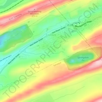
Name: Topografische Karte Coaldale, Höhe, Relief.
Ort: Coaldale, Schuylkill County, Pennsylvania, United States (40.80509 -75.93646 40.83388 -75.89154)
Durchschnittliche Höhe: 360 m
Minimale Höhe: 248 m
Maximale Höhe: 481 m
Andere topografische Karten
Klicken Sie auf eine Karte, um ihre Topografie, ihre Höhe und ihr Relief anzuzeigen.
Pottsville
United States > Pennsylvania > Schuylkill County > Pottsville
Durchschnittliche Höhe: 267 m