
Spenden
Rüste dich für dein nächstes Abenteuer:
Als Amazon-Partner verdient diese Website an qualifizierten Käufen, ohne zusätzliche Kosten für Sie.
Topografische Karte Mörtschach
Klicken Sie auf die Karte, um die Höhe anzuzeigen.
Spenden
Rüste dich für dein nächstes Abenteuer:
Als Amazon-Partner verdient diese Website an qualifizierten Käufen, ohne zusätzliche Kosten für Sie.
Über diese Karte
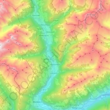
Name: Topografische Karte Mörtschach, Höhe, Relief.
Ort: Mörtschach, Bezirk Spittal an der Drau, Carinthia, Austria (46.87874 12.78295 46.98994 13.00216)
Durchschnittliche Höhe: 1.851 m
Minimale Höhe: 788 m
Maximale Höhe: 3.239 m
Spenden
Rüste dich für dein nächstes Abenteuer:
Als Amazon-Partner verdient diese Website an qualifizierten Käufen, ohne zusätzliche Kosten für Sie.
Andere topografische Karten
Klicken Sie auf eine Karte, um ihre Topografie, ihre Höhe und ihr Relief anzuzeigen.
Großglockner
Austria > Carinthia > Bezirk Spittal an der Drau > Heiligenblut am Großglockner
The Glockner is the highest mountain in the Alps east of the Ortler range, about 175 km (109 mi) away, and, after Mont Blanc, has the second greatest topographic isolation of all mountains in the Alps. Even its topographic prominence, at 2,424 m (7,953 ft), is the second highest after Mont Blanc in the entire…
Durchschnittliche Höhe: 3.128 m
Freier Seezugang Millstätter See bei Spittal an der Drau, Großegg
Austria > Carinthia > Bezirk Spittal an der Drau > Spittal an der Drau
Durchschnittliche Höhe: 677 m
Pasterze
Austria > Carinthia > Bezirk Spittal an der Drau > Heiligenblut am Großglockner
Durchschnittliche Höhe: 2.599 m
Sankt Wolfgang
Austria > Carinthia > Bezirk Spittal an der Drau > Seeboden am Millstätter See > Seebach
Durchschnittliche Höhe: 626 m
Spenden
Rüste dich für dein nächstes Abenteuer:
Als Amazon-Partner verdient diese Website an qualifizierten Käufen, ohne zusätzliche Kosten für Sie.
Untertauern
Austria > Carinthia > Bezirk Spittal an der Drau > Heiligenblut am Großglockner
Durchschnittliche Höhe: 1.682 m
Großglockner
Austria > Carinthia > Bezirk Spittal an der Drau > Heiligenblut am Großglockner
The Glockner is the highest mountain in the Alps east of the Ortler range, about 175 km (109 mi) away, and, after Mont Blanc, has the second greatest topographic isolation of all mountains in the Alps. Even its topographic prominence, at 2,424 m (7,953 ft), is the second highest after Mont Blanc in the entire…
Durchschnittliche Höhe: 3.128 m
Spenden
Rüste dich für dein nächstes Abenteuer:
Als Amazon-Partner verdient diese Website an qualifizierten Käufen, ohne zusätzliche Kosten für Sie.
Mohar
Austria > Carinthia > Bezirk Spittal an der Drau > Großkirchheim
Durchschnittliche Höhe: 2.213 m
Spenden
Rüste dich für dein nächstes Abenteuer:
Als Amazon-Partner verdient diese Website an qualifizierten Käufen, ohne zusätzliche Kosten für Sie.
Tangern
Austria > Carinthia > Bezirk Spittal an der Drau > Spittal an der Drau
Durchschnittliche Höhe: 691 m
Falkert
Austria > Carinthia > Bezirk Spittal an der Drau > Bad Kleinkirchheim
Durchschnittliche Höhe: 2.023 m
Großglockner
Austria > Carinthia > Bezirk Spittal an der Drau > Heiligenblut am Großglockner
The Glockner is the highest mountain in the Alps east of the Ortler range, about 175 km (109 mi) away, and, after Mont Blanc, has the second greatest topographic isolation of all mountains in the Alps. Even its topographic prominence, at 2,424 m (7,953 ft), is the second highest after Mont Blanc in the entire…
Durchschnittliche Höhe: 3.128 m
Spenden
Rüste dich für dein nächstes Abenteuer:
Als Amazon-Partner verdient diese Website an qualifizierten Käufen, ohne zusätzliche Kosten für Sie.
Großglockner
Austria > Carinthia > Bezirk Spittal an der Drau > Heiligenblut am Großglockner
The Glockner is the highest mountain in the Alps east of the Ortler range, about 175 km (109 mi) away, and, after Mont Blanc, has the second greatest topographic isolation of all mountains in the Alps. Even its topographic prominence, at 2,424 m (7,953 ft), is the second highest after Mont Blanc in the entire…
Durchschnittliche Höhe: 3.128 m
Techendorf
Austria > Carinthia > Bezirk Spittal an der Drau > Weißensee
Durchschnittliche Höhe: 1.183 m
Rothorn
Austria > Carinthia > Bezirk Spittal an der Drau > Dellach im Drautal
Durchschnittliche Höhe: 2.299 m
Spenden
Rüste dich für dein nächstes Abenteuer:
Als Amazon-Partner verdient diese Website an qualifizierten Käufen, ohne zusätzliche Kosten für Sie.
Heiligenblut
Austria > Carinthia > Bezirk Spittal an der Drau > Heiligenblut am Großglockner
Durchschnittliche Höhe: 1.982 m
Spenden
Rüste dich für dein nächstes Abenteuer:
Als Amazon-Partner verdient diese Website an qualifizierten Käufen, ohne zusätzliche Kosten für Sie.
Maltatal
Austria > Carinthia > Bezirk Spittal an der Drau > Gmünd in Kärnten
Durchschnittliche Höhe: 1.914 m
Hadergasse
Austria > Carinthia > Bezirk Spittal an der Drau > Heiligenblut am Großglockner
Durchschnittliche Höhe: 1.677 m