
Topografische Karte Lima
Interaktive Karte
Klicken Sie auf die Karte, um die Höhe anzuzeigen.
Über diese Karte
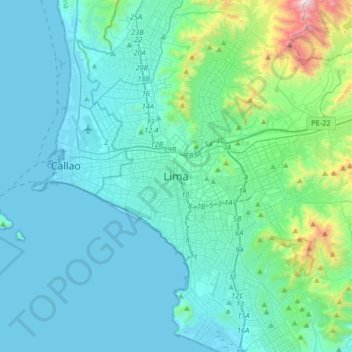
Name: Topografische Karte Lima, Höhe, Relief.
Durchschnittliche Höhe: 202 m
Minimale Höhe: 0 m
Maximale Höhe: 1.638 m
Relative humidity is always very high, particularly in the mornings. High humidity produces brief morning fog in the early summer and a usually persistent low cloud deck during the winter (generally develops in late May and persists until mid-November or even early December). The predominantly onshore flow makes the Lima area one of the cloudiest among the entire Peruvian coast. Lima has only 1284 hours of sunshine a year, 28.6 hours in July and 184 hours in April, which is exceptionally little for its latitude. By comparison, London has an average of 1653 hours of sunshine per year, and Moscow 1731 hours of sunshine per year. Winter cloudiness prompts locals to seek sunshine in Andean valleys located at elevations generally above 500 meters (1,600 ft) above sea level.