
Spenden
Rüste dich für dein nächstes Abenteuer:
Als Amazon-Partner verdient diese Website an qualifizierten Käufen, ohne zusätzliche Kosten für Sie.
Topografische Karte Wileyville
Klicken Sie auf die Karte, um die Höhe anzuzeigen.
Spenden
Rüste dich für dein nächstes Abenteuer:
Als Amazon-Partner verdient diese Website an qualifizierten Käufen, ohne zusätzliche Kosten für Sie.
Über diese Karte
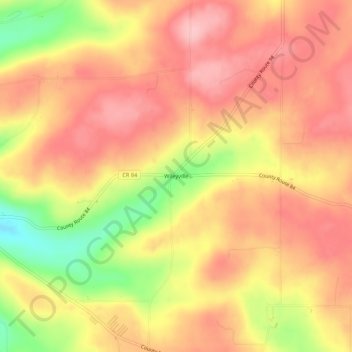
Name: Topografische Karte Wileyville, Höhe, Relief.
Durchschnittliche Höhe: 673 m
Minimale Höhe: 577 m
Maximale Höhe: 725 m
Spenden
Rüste dich für dein nächstes Abenteuer:
Als Amazon-Partner verdient diese Website an qualifizierten Käufen, ohne zusätzliche Kosten für Sie.
Andere topografische Karten
Klicken Sie auf eine Karte, um ihre Topografie, ihre Höhe und ihr Relief anzuzeigen.
Spenden
Rüste dich für dein nächstes Abenteuer:
Als Amazon-Partner verdient diese Website an qualifizierten Käufen, ohne zusätzliche Kosten für Sie.
City of Hornell
United States > New York > Steuben County
Hornell is located at 42°19′N 77°40′W / 42.317°N 77.667°W / 42.317; -77.667 (42.3244, -77.6603). Hornell is at an altitude of 1,160 feet (350 meters) above sea level.
Durchschnittliche Höhe: 461 m
Spenden
Rüste dich für dein nächstes Abenteuer:
Als Amazon-Partner verdient diese Website an qualifizierten Käufen, ohne zusätzliche Kosten für Sie.
Town of Prattsburgh
United States > New York > Steuben County
The town is at a higher altitude than most other parts of the county.
Durchschnittliche Höhe: 517 m
Spenden
Rüste dich für dein nächstes Abenteuer:
Als Amazon-Partner verdient diese Website an qualifizierten Käufen, ohne zusätzliche Kosten für Sie.
Village of Hammondsport
United States > New York > Steuben County
Beginning in 1894 Hammondsport received its first water system from springs that were contained in the Rufus Scofield farm, on Mt. Washington, not far from the village. Aside from supplying the village with pure spring water, one of the first objectives was to install five fire hydrants at convenient locations…
Durchschnittliche Höhe: 288 m
Spenden
Rüste dich für dein nächstes Abenteuer:
Als Amazon-Partner verdient diese Website an qualifizierten Käufen, ohne zusätzliche Kosten für Sie.
Spenden
Rüste dich für dein nächstes Abenteuer:
Als Amazon-Partner verdient diese Website an qualifizierten Käufen, ohne zusätzliche Kosten für Sie.
Coopers Plains
United States > New York > Steuben County > Town of Campbell > Coopers Plains
Durchschnittliche Höhe: 348 m
Spenden
Rüste dich für dein nächstes Abenteuer:
Als Amazon-Partner verdient diese Website an qualifizierten Käufen, ohne zusätzliche Kosten für Sie.