
Topografische Karte Panaji
Interaktive Karte
Klicken Sie auf die Karte, um die Höhe anzuzeigen.
Über diese Karte
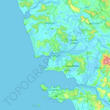
Name: Topografische Karte Panaji, Höhe, Relief.
Ort: Panaji, Tiswadi, North Goa District, Goa, 403001, India (15.33899 73.66821 15.65899 73.98821)
Durchschnittliche Höhe: 19 m
Minimale Höhe: -3 m
Maximale Höhe: 285 m
Panaji was annexed by India with the rest of Goa and the former Portuguese territories after the Indian annexation of Portuguese India in 1961. It became a state-capital on Goa's elevation to statehood in 1987and between 1961 and 1987, it was the capital of the Union Territory of Goa, Daman and Diu. A new Legislative Assembly complex was inaugurated in March 2000, across the Mandovi River, in Alto Porvorim. Panaji is also the administrative headquarters of North Goa district.