
Topografische Karte Lismore
Interaktive Karte
Klicken Sie auf die Karte, um die Höhe anzuzeigen.
Über diese Karte
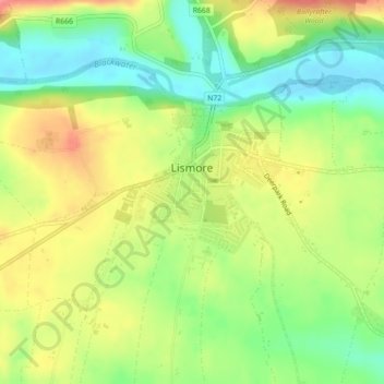
Name: Topografische Karte Lismore, Höhe, Relief.
Durchschnittliche Höhe: 38 m
Minimale Höhe: 2 m
Maximale Höhe: 79 m
Andere topografische Karten
Klicken Sie auf eine Karte, um ihre Topografie, ihre Höhe und ihr Relief anzuzeigen.
Mahon Falls
Mahon Falls, Mahon Falls Walk, Comeragh, The Municipal District of Comeragh, County Waterford, Munster, Ireland
Durchschnittliche Höhe: 575 m
St. Stephen's Within
Ireland > County Waterford > Waterford
St. Stephen's Within, Centre B, Waterford, County Waterford, Munster, Ireland
Durchschnittliche Höhe: 26 m
Crotty's Rock
Crotty's Rock, Ross, The Municipal District of Comeragh, County Waterford, Munster, Ireland
Durchschnittliche Höhe: 424 m
Millstreet
Millstreet, Ballynamult, The Municipal District of Dungarvan — Lismore, County Waterford, Munster, Ireland
Durchschnittliche Höhe: 112 m
Park
Ireland > County Waterford > Waterford
Park, Waterford, County Waterford, Munster, Ireland
Durchschnittliche Höhe: 22 m
Portlaw
Portlaw, The Municipal District of Comeragh, County Waterford, Munster, Ireland
Durchschnittliche Höhe: 76 m
Waterford City Metropolitan District
Waterford City Metropolitan District, County Waterford, Munster, Ireland
Durchschnittliche Höhe: 29 m
Dungarvan
Dungarvan, The Municipal District of Dungarvan — Lismore, County Waterford, Munster, X35 V670, Ireland
Durchschnittliche Höhe: 30 m
Waterford
Waterford, County Waterford, Munster, Ireland
Durchschnittliche Höhe: 33 m
County Waterford
County Waterford, Munster, Ireland
Durchschnittliche Höhe: 86 m