
Topografische Karte Darby
Interaktive Karte
Klicken Sie auf die Karte, um die Höhe anzuzeigen.
Über diese Karte
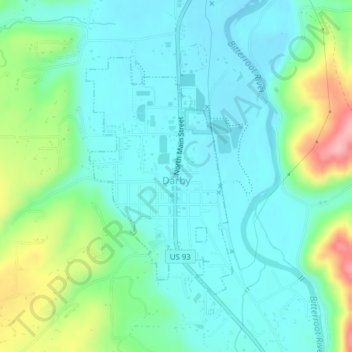
Name: Topografische Karte Darby, Höhe, Relief.
Ort: Darby, Ravalli County, Montana, United States (46.01387 -114.18807 46.03207 -114.17181)
Durchschnittliche Höhe: 1.210 m
Minimale Höhe: 1.174 m
Maximale Höhe: 1.316 m
Andere topografische Karten
Klicken Sie auf eine Karte, um ihre Topografie, ihre Höhe und ihr Relief anzuzeigen.
Big Sky Mobile Home Park
United States > Montana > Ravalli County
Big Sky Mobile Home Park, Ravalli County, Montana, 59840, United States
Durchschnittliche Höhe: 1.116 m
Sky Pilot
United States > Montana > Ravalli County
Sky Pilot, Ravalli County, Montana, United States
Durchschnittliche Höhe: 2.281 m