
Topografische Karte Dubnica nad Váhom
Interaktive Karte
Klicken Sie auf die Karte, um die Höhe anzuzeigen.
Dubnica nad Váhom
It is located on the Váh river, in the Ilava Basin, between the White Carpathians and Strážovské vrchy mountains, at an altitude of 242 metres. The town's cadastral area is composed of Dubnica and "city part" Prejta, annexed in 1973.
Über diese Karte
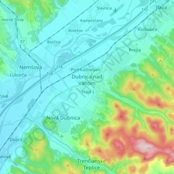
Name: Topografische Karte Dubnica nad Váhom, Höhe, Relief.
Durchschnittliche Höhe: 309 m
Minimale Höhe: 215 m
Maximale Höhe: 700 m