
Topografische Karte Neiz Vran
Interaktive Karte
Klicken Sie auf die Karte, um die Höhe anzuzeigen.
Über diese Karte
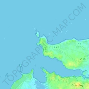
Name: Topografische Karte Neiz Vran, Höhe, Relief.
Durchschnittliche Höhe: 2 m
Minimale Höhe: -1 m
Maximale Höhe: 18 m
Andere topografische Karten
Klicken Sie auf eine Karte, um ihre Topografie, ihre Höhe und ihr Relief anzuzeigen.
Stréatveur
France > Bretagne > Finistère > Kerlouan
Stréatveur, Kerlouan, Brest, Finistère, Bretagne, France métropolitaine, 29890, France
Durchschnittliche Höhe: 9 m
Boutrouilles
France > Bretagne > Finistère > Kerlouan
Boutrouilles, Kerlouan, Brest, Finistère, Bretagne, France métropolitaine, 29890, France
Durchschnittliche Höhe: 3 m
Maner Drolic
France > Bretagne > Finistère > Kerlouan > Maner Drolic
Maner Drolic, Kerlouan, Brest, Finistère, Bretagne, France métropolitaine, 29890, France
Durchschnittliche Höhe: 7 m