
Topografische Karte Kigoma
Interaktive Karte
Klicken Sie auf die Karte, um die Höhe anzuzeigen.
Kigoma
Kigoma Region is on a plateau that slopes from the northeast at about 1,750 meters down to 800 meters at the shore of lake Tanganyika. The topography in the north and east is gently rolling hills that gradually become steeper as they get closer to the Albertine Rift margin. The most important river is the Malagarasi, with the Luiche and the Ruchugi being the two other major rivers draining the region.
Über diese Karte
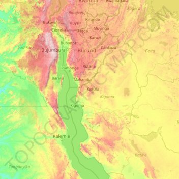
Name: Topografische Karte Kigoma, Höhe, Relief.
Ort: Kigoma, Western Zone, Tanzania (-7.07266 27.44505 -1.95266 32.56505)
Durchschnittliche Höhe: 1.174 m
Minimale Höhe: 557 m
Maximale Höhe: 3.421 m