Geolokalisieren
👉 Easily get elevation data in JSON, GeoTIFF and KML formats using Elevation API
Vielen Dank für die Unterstützung dieser Website ❤️
Spenden

Rüste dich für dein nächstes Abenteuer:

Als Amazon-Partner verdient diese Website an qualifizierten Käufen, ohne zusätzliche Kosten für Sie.

Topografische Karte Mount Buggery

Klicken Sie auf die Karte, um die Höhe anzuzeigen.

👉 Easily get elevation data in JSON, GeoTIFF and KML formats using Elevation API
Vielen Dank für die Unterstützung dieser Website ❤️
Spenden

Rüste dich für dein nächstes Abenteuer:

Als Amazon-Partner verdient diese Website an qualifizierten Käufen, ohne zusätzliche Kosten für Sie.

Über diese Karte

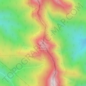
Name: Topografische Karte Mount Buggery, Höhe, Relief.

Ort: Mount Buggery, Shire of Wellington, Victoria, Australia (-37.14169 146.64047 -37.14159 146.64057)

Durchschnittliche Höhe: 1.286 m

Minimale Höhe: 982 m

Maximale Höhe: 1.642 m

Andere topografische Karten

Klicken Sie auf eine Karte, um ihre Topografie, ihre Höhe und ihr Relief anzuzeigen.

City of Melbourne

Australia > Victoria

Melbourne's topography is characterized by a diverse landscape that transitions from flat coastal plains to rolling hills and mountainous regions. The city is situated at the northern end of Port Phillip Bay, where the terrain is predominantly flat, facilitating urban development. As one moves eastward, the…

Durchschnittliche Höhe: 18 m

Melbourne

Australia > Victoria

Melbourne is also prone to isolated convective showers forming when a cold pool crosses the state, especially if there is considerable daytime heating. These showers are often heavy and can include hail, squalls, and significant drops in temperature, but they often pass through very quickly with a rapid…

Durchschnittliche Höhe: 185 m

Glen Waverley

Australia > Victoria

Durchschnittliche Höhe: 103 m

Wilsons Promontory National Park

Australia > Victoria

Durchschnittliche Höhe: 32 m

Greensborough

Australia > Victoria

Durchschnittliche Höhe: 83 m

Mount Buller

Australia > Victoria

Due to its far south-western location in the alpine region, Mount Buller is more susceptible to cold airmasses which allow it to record some of the lowest maximum temperatures and daytime readings in the country, despite being considerably lower in elevation than other mountain sites to the north-east. On 5…

Durchschnittliche Höhe: 824 m

Warrnambool

Australia > Victoria

Durchschnittliche Höhe: 19 m

Lakes Entrance

Australia > Victoria

Durchschnittliche Höhe: 39 m

Gippsland

Australia > Victoria

Durchschnittliche Höhe: 273 m

Grampians National Park

Australia > Victoria

Mount William is known within the gliding community for the "Grampians Wave", a weather phenomenon that sometimes enables glider pilots to reach extreme altitudes of the order of 28,000 ft (8,500 m). This predominantly occurs during the months of May, June, September and October when strong westerly winds flow…

Durchschnittliche Höhe: 262 m

Smiths Beach

Australia > Victoria

Durchschnittliche Höhe: 24 m

Vielen Dank für die Unterstützung dieser Website ❤️
Spenden

Rüste dich für dein nächstes Abenteuer:

Als Amazon-Partner verdient diese Website an qualifizierten Käufen, ohne zusätzliche Kosten für Sie.

Elwood

Australia > Victoria > Melbourne

Durchschnittliche Höhe: 8 m

Point Cook

Australia > Victoria > Melbourne

Durchschnittliche Höhe: 8 m

Flowerdale

Australia > Victoria

Durchschnittliche Höhe: 402 m

Glen Iris

Australia > Victoria

Durchschnittliche Höhe: 46 m

Omeo

Australia > Victoria

There are bus routes from Bright and Bairnsdale. The Bairnsdale bus runs weekdays, once both directions, and the Bright bus (Alps Link) timetable is less frequent in Summer and runs additional services during the ski season. Alps Link is the highest altitude public bus in Australia. The town sits at the…

Durchschnittliche Höhe: 861 m

Frankston

Australia > Victoria

Olivers Hill is the most prominent elevation in Frankston which rises to 55 metres above sea level (180 feet) at its highest point in the suburb. Its origins date to approximately 415 to 360 million years ago. Its base is Mount Eliza Granite dating from the Devonian period, which was covered in lava tuffs in…

Durchschnittliche Höhe: 40 m

Great Otway National Park

Australia > Victoria

Durchschnittliche Höhe: 91 m

Woodend

Australia > Victoria

Durchschnittliche Höhe: 603 m

Vielen Dank für die Unterstützung dieser Website ❤️
Spenden

Rüste dich für dein nächstes Abenteuer:

Als Amazon-Partner verdient diese Website an qualifizierten Käufen, ohne zusätzliche Kosten für Sie.

Wabonga

Australia > Victoria

Durchschnittliche Höhe: 904 m

Tarwin Lower

Australia > Victoria

Durchschnittliche Höhe: 28 m

Warburton

Australia > Victoria

Durchschnittliche Höhe: 525 m

Doncaster East

Australia > Victoria

Durchschnittliche Höhe: 89 m

Aberfeldie

Australia > Victoria > Melbourne

Durchschnittliche Höhe: 27 m

Maribyrnong

Australia > Victoria

Durchschnittliche Höhe: 23 m

Altona North

Australia > Victoria > Melbourne

Durchschnittliche Höhe: 15 m

Keilor

Australia > Victoria > Melbourne

Durchschnittliche Höhe: 72 m

Dingley Village

Australia > Victoria

Durchschnittliche Höhe: 26 m

Eltham District

Australia > Victoria > Greensborough

Durchschnittliche Höhe: 85 m

Dandenong Ranges National Park - Ferntree Gully

Australia > Victoria > Montrose

The topography consists of a series of ridges dissected by deeply cut streams. Sheltered gullies in the south of the range are home to temperate rain forest, fern gullies and Mountain Ash forest Eucalyptus regnans, whereas the drier ridges and exposed northern slopes are covered by dry sclerophyll forest of…

Durchschnittliche Höhe: 345 m

Drouin

Australia > Victoria

Durchschnittliche Höhe: 121 m

Shire of Mansfield

Australia > Victoria

Durchschnittliche Höhe: 748 m

French Island

Australia > Victoria

Durchschnittliche Höhe: 12 m

Mordialloc

Australia > Victoria

Durchschnittliche Höhe: 10 m

Wheelers Hill

Australia > Victoria

Durchschnittliche Höhe: 85 m

Echuca

Australia > Victoria

Durchschnittliche Höhe: 100 m

Halls Gap

Australia > Victoria

Durchschnittliche Höhe: 406 m

Yackandandah

Australia > Victoria

Durchschnittliche Höhe: 469 m

Torquay

Australia > Victoria

Durchschnittliche Höhe: 32 m

Blackburn

Australia > Victoria

Durchschnittliche Höhe: 103 m

Wandiligong

Australia > Victoria

Durchschnittliche Höhe: 657 m

Port Phillip

Australia > Victoria

Port Phillip's mostly flat topography and moderate waves make perfect conditions for recreational swimming, kitesurfing, windsurfing, sailing, boating, snorkeling, scuba diving, stand up paddle boarding (SUP) and other sports.

Durchschnittliche Höhe: 18 m

Chadstone

Australia > Victoria

Durchschnittliche Höhe: 67 m

Port Fairy

Australia > Victoria

Durchschnittliche Höhe: 22 m

Lerderderg State Park

Australia > Victoria

Durchschnittliche Höhe: 459 m

Newstead

Australia > Victoria

Durchschnittliche Höhe: 247 m

Forrest

Australia > Victoria

Hemmed in by a rising ocean that stabilised about 7000 years ago, the uplifted sedimentary rocks of the Otway Range run from north-east to south-west at an elevation of about 500 metres above the sea. A few isolated peaks reach up to 675 metres, and at many points along this coastline bare mountains and…

Durchschnittliche Höhe: 212 m

Matlock

Australia > Victoria

Durchschnittliche Höhe: 889 m

Woods Point

Australia > Victoria

Durchschnittliche Höhe: 878 m

Morrisons

Australia > Victoria

Durchschnittliche Höhe: 372 m

Mount Beauty

Australia > Victoria

The town has a prominent winter rainfall peak, with a yearly average of 1,264.6 millimetres (49.79 in). It rains on 142 days of the year; heavily concentrated between May and October. On account of its southern latitude nearing the 37th parallel, summers have a notable chill about them when compared to…

Durchschnittliche Höhe: 884 m

Cann River

Australia > Victoria

Durchschnittliche Höhe: 111 m

Balook

Australia > Victoria

Durchschnittliche Höhe: 432 m

Wodonga

Australia > Victoria

Durchschnittliche Höhe: 191 m

Hawthorn

Australia > Victoria > Melbourne

Durchschnittliche Höhe: 33 m

Alphington

Australia > Victoria

Durchschnittliche Höhe: 35 m

Armstrong Creek

Australia > Victoria > Geelong

Durchschnittliche Höhe: 47 m

Moe

Australia > Victoria

Durchschnittliche Höhe: 79 m

Mornington District

Australia > Victoria > Melbourne

Durchschnittliche Höhe: 50 m

Templestowe

Australia > Victoria > Melbourne

Gentle, rolling hills extend from east of the Yarra River flood plains, along Templestowe Road (towards the Eastern Freeway) for seven km (4.3 miles), to the north-east. The altitude of the plain above sea level is 50 m, and the topography is subdued and mostly flat; the hills are just below 60 m, the slopes…

Durchschnittliche Höhe: 66 m

Traralgon

Australia > Victoria

Durchschnittliche Höhe: 53 m

Hastings District

Australia > Victoria > Koo Wee Rup > Clyde

Durchschnittliche Höhe: 14 m

Kilmore

Australia > Victoria

Durchschnittliche Höhe: 349 m

Mount Evelyn

Australia > Victoria

Durchschnittliche Höhe: 189 m

Lake Eildon National Park

Australia > Victoria

Durchschnittliche Höhe: 473 m

Bendigo Creek

Australia > Victoria > Bendigo

Durchschnittliche Höhe: 227 m

Lake Eildon

Australia > Victoria

Durchschnittliche Höhe: 386 m

Lake Eppalock

Australia > Victoria

Durchschnittliche Höhe: 219 m

Swan Hill

Australia > Victoria

Durchschnittliche Höhe: 72 m

Fitzroy

Australia > Victoria > Melbourne

Fitzroy's topography is flat. It is laid out in grid plan and is characterised by a fairly tightly spaced rectangular grid of medium-sized streets, with many of its narrow streets and back lanes facilitating only one-way traffic. Its built form is a legacy of its early history when a mixture of land uses was…

Durchschnittliche Höhe: 35 m

Cobungra

Australia > Victoria

Durchschnittliche Höhe: 1.124 m

West Melbourne

Australia > Victoria > Melbourne

Durchschnittliche Höhe: 8 m

Knoxfield

Australia > Victoria > Melbourne

Durchschnittliche Höhe: 80 m

Olinda

Australia > Victoria > Melbourne

Durchschnittliche Höhe: 370 m

Kew

Australia > Victoria > Melbourne

Durchschnittliche Höhe: 38 m

Harrietville

Australia > Victoria

Durchschnittliche Höhe: 1.018 m

Wonthaggi

Australia > Victoria

Durchschnittliche Höhe: 23 m

Port Melbourne

Australia > Victoria > Melbourne

Durchschnittliche Höhe: 4 m

Diamond Creek

Australia > Victoria

Durchschnittliche Höhe: 75 m

Kyneton

Australia > Victoria

Durchschnittliche Höhe: 504 m

Docklands

Australia > Victoria

Durchschnittliche Höhe: 9 m

Mount Eliza

Australia > Victoria > Melbourne

Durchschnittliche Höhe: 60 m

Bright

Australia > Victoria

Durchschnittliche Höhe: 550 m

Donvale

Australia > Victoria > Melbourne

Durchschnittliche Höhe: 108 m

Thornbury

Australia > Victoria

Durchschnittliche Höhe: 54 m

Kinglake National Park

Australia > Victoria > Kinglake

Durchschnittliche Höhe: 358 m

Portland

Australia > Victoria

Durchschnittliche Höhe: 20 m

Shire of South Gippsland

Australia > Victoria

Durchschnittliche Höhe: 81 m

Morwell

Australia > Victoria

Durchschnittliche Höhe: 61 m

Huntly

Australia > Victoria

Durchschnittliche Höhe: 180 m

Melton

Australia > Victoria > Melbourne

Durchschnittliche Höhe: 146 m

Mt Taylor

Australia > Victoria

Durchschnittliche Höhe: 217 m

Tawonga South

Australia > Victoria

Durchschnittliche Höhe: 752 m

Western Port

Australia > Victoria

Formerly a major river drainage system, it was inundated together with Port Phillip by the rising sea in the Holocene period; the Western Port sunkland now forms an extensive tidal bay. The waters of Western Port cover an area of 680 km² of which 270 km² are exposed as mud flats at low tide. The topography…

Durchschnittliche Höhe: 35 m

Sale

Australia > Victoria

Durchschnittliche Höhe: 8 m

Vielen Dank für die Unterstützung dieser Website ❤️
Spenden

Mount Macedon

Australia > Victoria

Due to its relatively high elevation of approximately 620 metres (2,030 ft) AHD, the area experiences much cooler temperatures on average relative to nearby Melbourne. The area also receives high rainfall relative to the surrounding plains and much of the Melbourne area. This combination of geographic factors…

Durchschnittliche Höhe: 673 m

French Island

Australia > Victoria > French Island

Durchschnittliche Höhe: 12 m

Taggerty

Australia > Victoria

Durchschnittliche Höhe: 404 m

Selwyn

Australia > Victoria

Durchschnittliche Höhe: 1.094 m

Rüste dich für dein nächstes Abenteuer:

💧Wasserfilter Outdoor - Sauberes Trinkwasser aus natürlichen Quellen
🎒Rucksack 30L - Ideale Größe für Tageswanderungen
🥘Outdoor Kochgeschirr - Robuste Sets für Camping und Trekking
🧥Wander-Regenponcho - Schneller Schutz für Wanderer und Rucksack bei Gewittern
🩹Erste Hilfe am Berg - Anleitungen zur Versorgung von Unfällen in der Natur

Als Amazon-Partner verdient diese Website an qualifizierten Käufen, ohne zusätzliche Kosten für Sie.