
Topografische Karte Saint-Nazaire
Interaktive Karte
Klicken Sie auf die Karte, um die Höhe anzuzeigen.
Über diese Karte
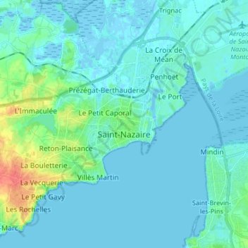
Name: Topografische Karte Saint-Nazaire, Höhe, Relief.
Durchschnittliche Höhe: 6 m
Minimale Höhe: -5 m
Maximale Höhe: 46 m
According to INSEE, Saint-Nazaire is the commune-center of an urban unit (commonly: agglomeration) which counted 186,760 inhabitants in 2018, gathering 17 communes of the Loire estuary. This unit is the urban center of the urban area of Saint-Nazaire (24 communes), which had 213,675 inhabitants in 2018 and extending over Brière and almost all of the Guérande peninsula. The eastern part of the town is on the alluvial terrain between the Brière and the Loire estuary. The western part, more extensive, corresponds to the extension of the hillside of Guérande: the relief is hilly and of higher altitude, where one finds a granite and metamorphic base. Geologically, Saint-Nazaire is located in the Armorican massif.
Andere topografische Karten
Klicken Sie auf eine Karte, um ihre Topografie, ihre Höhe und ihr Relief anzuzeigen.
Savenay
France > Pays de la Loire > Loire-Atlantique
Savenay, Saint-Nazaire, Loire-Atlantique, Pays de la Loire, Metropolitan France, 44260, France
Durchschnittliche Höhe: 35 m
Saint-Père-en-Retz
France > Pays de la Loire > Loire-Atlantique > Saint-Père-en-Retz
Saint-Père-en-Retz, Saint-Nazaire, Loire-Atlantique, Pays de la Loire, Metropolitan France, 44320, France
Durchschnittliche Höhe: 19 m
Nantes
France > Pays de la Loire > Loire-Atlantique
Nantes, Loire-Atlantique, Pays de la Loire, Metropolitan France, France
Durchschnittliche Höhe: 26 m