
Topografische Karte Ficksburg
Interaktive Karte
Klicken Sie auf die Karte, um die Höhe anzuzeigen.
Über diese Karte
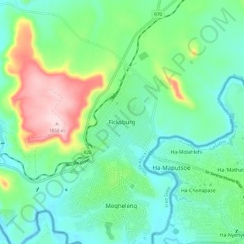
Name: Topografische Karte Ficksburg, Höhe, Relief.
Durchschnittliche Höhe: 1.617 m
Minimale Höhe: 1.528 m
Maximale Höhe: 1.856 m
Andere topografische Karten
Klicken Sie auf eine Karte, um ihre Topografie, ihre Höhe und ihr Relief anzuzeigen.
Setsoto Ward 3
South Africa > Free State > Thabo Mofutsanyana District Municipality > Setsoto Local Municipality
Setsoto Ward 3, Setsoto Local Municipality, Thabo Mofutsanyana District Municipality, Free State, South Africa
Durchschnittliche Höhe: 1.516 m
Hlohlolwane (Clocolan)
South Africa > Free State > Thabo Mofutsanyana District Municipality > Setsoto Local Municipality
Hlohlolwane (Clocolan), Setsoto Local Municipality, Thabo Mofutsanyana District Municipality, Free State, 9735, South Africa
Durchschnittliche Höhe: 1.593 m
Senekal
South Africa > Free State > Thabo Mofutsanyana District Municipality > Setsoto Local Municipality
Senekal, Setsoto Local Municipality, Thabo Mofutsanyana District Municipality, Free State, South Africa
Durchschnittliche Höhe: 1.451 m
Marquard
South Africa > Free State > Thabo Mofutsanyana District Municipality > Setsoto Local Municipality > Marquard
Marquard, Setsoto Local Municipality, Thabo Mofutsanyana District Municipality, Free State, 9610, South Africa
Durchschnittliche Höhe: 1.512 m