
Topografische Karte Saxon
Klicken Sie auf die Karte, um die Höhe anzuzeigen.
Über diese Karte
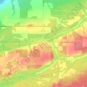
Name: Topografische Karte Saxon, Höhe, Relief.
Durchschnittliche Höhe: 339 m
Minimale Höhe: 290 m
Maximale Höhe: 371 m
Andere topografische Karten
Klicken Sie auf eine Karte, um ihre Topografie, ihre Höhe und ihr Relief anzuzeigen.
Hurley
United States > Wisconsin > Iron County
Hurley was at the center of a boundary dispute between Michigan and Wisconsin, culminating in a United States Supreme Court case in 1926, confirming Hurley belonging to Wisconsin. The Montreal River was mapped in detail in 1841 by Lieutenant Thomas Jefferson Cram of the United States Land Office Department of…
Durchschnittliche Höhe: 455 m
Manitowish River
United States > Wisconsin > Iron County > Town of Mercer > Manitowish
Durchschnittliche Höhe: 486 m