
Topografische Karte Town of Binghamton
Interaktive Karte
Klicken Sie auf die Karte, um die Höhe anzuzeigen.
Über diese Karte
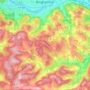
Name: Topografische Karte Town of Binghamton, Höhe, Relief.
Durchschnittliche Höhe: 417 m
Minimale Höhe: 247 m
Maximale Höhe: 573 m
Andere topografische Karten
Klicken Sie auf eine Karte, um ihre Topografie, ihre Höhe und ihr Relief anzuzeigen.
Town of Nanticoke
United States > New York > Broome County
Town of Nanticoke, Broome County, New York, 13777, United States
Durchschnittliche Höhe: 396 m
Crocker Island
United States > New York > Broome County > Village of Johnson City
Crocker Island, Village of Johnson City, Town of Union, Broome County, New York, 13902, United States
Durchschnittliche Höhe: 411 m
Nineveh
United States > New York > Broome County
Nineveh, Town of Colesville, Broome County, New York, United States
Durchschnittliche Höhe: 338 m
City of Binghamton
United States > New York > Broome County
City of Binghamton, Broome County, New York, 13905, United States
Durchschnittliche Höhe: 321 m
Oquaga Lake
United States > New York > Broome County > Town of Sanford
Oquaga Lake, Town of Sanford, Broome County, New York, United States
Durchschnittliche Höhe: 515 m
Binghamton
United States > New York > Broome County > Binghamton
Binghamton, Broome County, New York, 13903, United States
Durchschnittliche Höhe: 397 m
Town of Vestal
United States > New York > Broome County
Town of Vestal, Union, Broome County, New York, United States
Durchschnittliche Höhe: 372 m
Village of Johnson City
United States > New York > Broome County
Village of Johnson City, Town of Union, Broome County, New York, 13790, United States
Durchschnittliche Höhe: 309 m
Flowers
United States > New York > Broome County > Flowers
Flowers, Windsor Town, Broome County, New York, 13865, United States
Durchschnittliche Höhe: 484 m
Village of Deposit
United States > New York > Broome County
Village of Deposit, Town of Sanford, Broome County, New York, United States
Durchschnittliche Höhe: 356 m