
Topografische Karte Clanwilliam
Interaktive Karte
Klicken Sie auf die Karte, um die Höhe anzuzeigen.
Über diese Karte
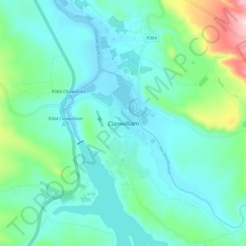
Name: Topografische Karte Clanwilliam, Höhe, Relief.
Durchschnittliche Höhe: 162 m
Minimale Höhe: 72 m
Maximale Höhe: 536 m
Clanwilliam is situated at an elevation of 100 metres (330 ft), between the western slopes of the Cederberg mountains and the east bank of the Olifants River, which is impounded there by the Clanwilliam Dam. It is located just off the N7 national road, which runs from Cape Town to the Namibian border, and on the R364 road, which runs from Lamberts Bay to Calvinia. Clanwilliam is 230 kilometres (140 mi) from Cape Town by road.
Andere topografische Karten
Klicken Sie auf eine Karte, um ihre Topografie, ihre Höhe und ihr Relief anzuzeigen.
Algeria
South Africa > Western Cape > West Coast District Municipality > Cederberg Local Municipality
Algeria, Cederberg Local Municipality, West Coast District Municipality, Western Cape, South Africa
Durchschnittliche Höhe: 781 m
Pankop
South Africa > Western Cape > West Coast District Municipality > Cederberg Local Municipality
Pankop, Cederberg Local Municipality, West Coast District Municipality, Western Cape, South Africa
Durchschnittliche Höhe: 260 m
Elandsbaai
South Africa > Western Cape > West Coast District Municipality > Cederberg Local Municipality
Elandsbaai, Cederberg Local Municipality, West Coast District Municipality, Western Cape, 8101, South Africa
Durchschnittliche Höhe: 43 m
Citrusdal
South Africa > Western Cape > West Coast District Municipality > Cederberg Local Municipality
Citrusdal, Cederberg Local Municipality, West Coast District Municipality, Western Cape, 7340, South Africa
Durchschnittliche Höhe: 256 m
Bulshoek Dam
South Africa > Western Cape > West Coast District Municipality > Cederberg Local Municipality
Bulshoek Dam, Cederberg Ward 6, Cederberg Local Municipality, West Coast District Municipality, Western Cape, South Africa
Durchschnittliche Höhe: 184 m
Cederberg
South Africa > Western Cape > West Coast District Municipality > Cederberg Local Municipality
Cederberg, Cederberg Local Municipality, West Coast District Municipality, Western Cape, South Africa
Durchschnittliche Höhe: 997 m
Wolfberg
South Africa > Western Cape > West Coast District Municipality > Cederberg Local Municipality
Wolfberg, Cederberg Local Municipality, West Coast District Municipality, Western Cape, South Africa
Durchschnittliche Höhe: 1.399 m
Wolfberg Arch
South Africa > Western Cape > West Coast District Municipality > Cederberg Local Municipality > Cederberg
Wolfberg Arch, Die Trap, Cederberg Ward 1, Cederberg, Cederberg Local Municipality, West Coast District Municipality, Western Cape, South Africa
Durchschnittliche Höhe: 1.413 m
Cederberg Ward 1
South Africa > Western Cape > West Coast District Municipality > Cederberg Local Municipality
Cederberg Ward 1, Cederberg Local Municipality, West Coast District Municipality, Western Cape, South Africa
Durchschnittliche Höhe: 690 m
Wupperthal
South Africa > Western Cape > West Coast District Municipality > Cederberg Local Municipality
Wupperthal, Cederberg Local Municipality, West Coast District Municipality, Western Cape, South Africa
Durchschnittliche Höhe: 636 m