Geolokalisieren

Topografische Karte 付家屯

Interaktive Karte

Klicken Sie auf die Karte, um die Höhe anzuzeigen.

Über diese Karte

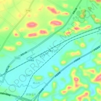
Name: Topografische Karte 付家屯, Höhe, Relief.

Ort: 付家屯, 西秀区, 安顺市, 贵州省, 中国 (26.18484 105.86090 26.22484 105.90090)

Durchschnittliche Höhe: 1.371 m

Minimale Höhe: 1.322 m

Maximale Höhe: 1.480 m

Andere topografische Karten

Klicken Sie auf eine Karte, um ihre Topografie, ihre Höhe und ihr Relief anzuzeigen.

白水镇

中国 > 贵州省 > 安顺市

白水镇, 安顺市, 贵州省, 中国

Durchschnittliche Höhe: 1.043 m

乐平镇

中国 > 贵州省 > 安顺市

乐平镇, 安顺市, 贵州省, 中国

Durchschnittliche Höhe: 1.383 m

齐伯镇

中国 > 贵州省 > 安顺市

齐伯镇, 安顺市, 贵州省, 中国

Durchschnittliche Höhe: 1.279 m

双堡镇

中国 > 贵州省 > 安顺市

双堡镇, 安顺市, 贵州省, 中国

Durchschnittliche Höhe: 1.278 m

西秀区

中国 > 贵州省 > 安顺市

西秀区, 安顺市, 贵州省, 561000, 中国

Durchschnittliche Höhe: 1.322 m

普定县

中国 > 贵州省 > 安顺市

普定县, 安顺市, 贵州省, 中国

Durchschnittliche Höhe: 1.425 m

镇宁布依族苗族自治县

中国 > 贵州省 > 安顺市

镇宁布依族苗族自治县, 安顺市, 贵州省, 中国

Durchschnittliche Höhe: 1.139 m

关岭布依族苗族自治县

中国 > 贵州省 > 安顺市

关岭布依族苗族自治县, 安顺市, 贵州省, 中国

Durchschnittliche Höhe: 1.121 m

哑里

中国 > 贵州省 > 安顺市 > 哑里

哑里, 安顺市, 贵州省, 中国

Durchschnittliche Höhe: 1.527 m