
Topografische Karte Oriskany
Interaktive Karte
Klicken Sie auf die Karte, um die Höhe anzuzeigen.
Über diese Karte
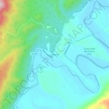
Name: Topografische Karte Oriskany, Höhe, Relief.
Ort: Oriskany, Botetourt County, Virginia, 24130, United States (37.59652 -80.00366 37.63652 -79.96366)
Durchschnittliche Höhe: 404 m
Minimale Höhe: 319 m
Maximale Höhe: 750 m
Andere topografische Karten
Klicken Sie auf eine Karte, um ihre Topografie, ihre Höhe und ihr Relief anzuzeigen.
Fincastle
United States > Virginia > Botetourt County
Fincastle, Botetourt County, Virginia, 24090, United States
Durchschnittliche Höhe: 363 m
Blue Ridge Mountains
United States > Virginia > Botetourt County
Blue Ridge Mountains, Botetourt County, Virginia, United States
Durchschnittliche Höhe: 460 m
Troutville
United States > Virginia > Botetourt County
Troutville, Botetourt County, Virginia, United States
Durchschnittliche Höhe: 458 m
Eagle Rock
United States > Virginia > Botetourt County
Eagle Rock, Botetourt County, Virginia, 24085, United States
Durchschnittliche Höhe: 379 m
Daleville
United States > Virginia > Botetourt County
Daleville, Botetourt County, Virginia, 24083, United States
Durchschnittliche Höhe: 410 m
Cloverdale
United States > Virginia > Botetourt County
Cloverdale, Runaway Village, Botetourt County, Virginia, United States
Durchschnittliche Höhe: 401 m
Glen Wilton
United States > Virginia > Botetourt County
Glen Wilton, Botetourt County, Virginia, 24438, United States
Durchschnittliche Höhe: 363 m
Coyner Mountain Overlook
United States > Virginia > Botetourt County
Coyner Mountain Overlook, Botetourt County, Virginia, 25012, United States
Durchschnittliche Höhe: 381 m
Daleville
United States > Virginia > Botetourt County
Daleville, Botetourt County, Virginia, 24083, United States
Durchschnittliche Höhe: 412 m
Haden
United States > Virginia > Botetourt County > Haden
Haden, Botetourt County, Virginia, 24438, United States
Durchschnittliche Höhe: 339 m
Buchanan
United States > Virginia > Botetourt County
Buchanan, Botetourt County, Virginia, 24066, United States
Durchschnittliche Höhe: 344 m
Laymantown
United States > Virginia > Botetourt County > Laymantown
Laymantown, Botetourt County, Virginia, United States
Durchschnittliche Höhe: 412 m
Blue Ridge
United States > Virginia > Botetourt County
Blue Ridge, Botetourt County, Virginia, United States
Durchschnittliche Höhe: 472 m