
Topografische Karte Norman
Interaktive Karte
Klicken Sie auf die Karte, um die Höhe anzuzeigen.
Norman
Norman and the surrounding areas are mostly flat with an elevation near 1,171 ft (357 m). The terrain in the western section of Norman is prairie, while the eastern section, including the area surrounding Lake Thunderbird, consists of some 6,000 acres (24 km2) of lakes and Cross Timbers forest. The lowest point within city limits is approximately 970 ft (296 m) above sea level (located at 35.20388N, 97.17735W). The highest point is approximately 1,245 ft (379 m) above sea level (located at 35.21266N, 97.39000W).
Über diese Karte
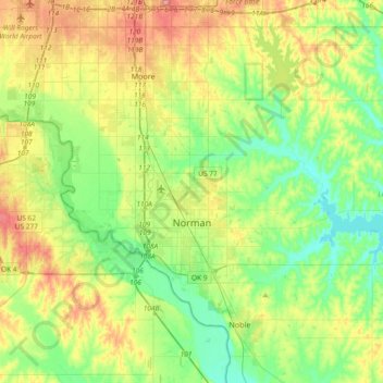
Name: Topografische Karte Norman, Höhe, Relief.
Ort: Norman, Cleveland County, Oklahoma, United States (35.14532 -97.54745 35.34832 -97.17692)
Durchschnittliche Höhe: 358 m
Minimale Höhe: 317 m
Maximale Höhe: 432 m
Andere topografische Karten
Klicken Sie auf eine Karte, um ihre Topografie, ihre Höhe und ihr Relief anzuzeigen.
Southwest Oklahoma City Sludge Lagoon Dam
United States > Oklahoma > Cleveland County > Oklahoma City
Durchschnittliche Höhe: 348 m
Lake Thunderbird Dam
United States > Oklahoma > Cleveland County > Norman > Little Axe
Durchschnittliche Höhe: 318 m