
Topografische Karte Rafsanjan
Interaktive Karte
Klicken Sie auf die Karte, um die Höhe anzuzeigen.
Über diese Karte
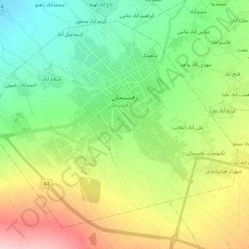
Name: Topografische Karte Rafsanjan, Höhe, Relief.
Ort: Rafsanjan, بخش مرکزی, Rafsanjan County, Kerman Province, Iran (30.32710 55.90445 30.44527 56.06907)
Durchschnittliche Höhe: 1.539 m
Minimale Höhe: 1.477 m
Maximale Höhe: 1.653 m
Rafsanjan is located in south part of the Lut desert, in north-west of Kerman province. The longitude of this city is 56 degrees east and the latitude is 30 degrees south. The Average distance between Kerman and this city is 110 km (68 mi). The city has an airport and railway (Tehran-Bandar Abbas route). Moreover, the altitude is 1,460 m (4,790 ft) and the land-measurement is approximately 10,687 km (6,641 mi). North part of Rafsanjan has a common frontier with Bafgh and Zarand; south part is neighboring with Bardsir and on west side with Anar and Shahre-Babak; finally east side of this city is neighboring with Kerman and Zarand. Rafsanjan has two seasonal rivers named as Shour and Giouderi. The mountains in the area are part of Zagros range, and Sarcheshmeh and Davaran are the most famous.
Andere topografische Karten
Klicken Sie auf eine Karte, um ihre Topografie, ihre Höhe und ihr Relief anzuzeigen.
دهستان بهرمان
Iran > Kerman Province > Rafsanjan County
دهستان بهرمان, بخش نوق, Rafsanjan County, Kerman Province, Iran
Durchschnittliche Höhe: 1.463 m