
Topografische Karte Jordan Lake
Interaktive Karte
Klicken Sie auf die Karte, um die Höhe anzuzeigen.
Über diese Karte
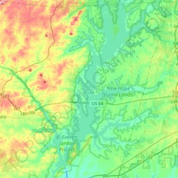
Name: Topografische Karte Jordan Lake, Höhe, Relief.
Ort: Jordan Lake, Chatham County, North Carolina, United States (35.64128 -79.10467 35.86993 -78.94848)
Durchschnittliche Höhe: 102 m
Minimale Höhe: 52 m
Maximale Höhe: 223 m
The Jordan Lake Dam (also known as the B. Everett Jordan Project and the New Hope Dam) is located at 35°39′15″N 79°4′0″W / 35.65417°N 79.06667°W / 35.65417; -79.06667 (B. Everett Jordan Dam) 4 miles (6.4 km) upstream from the mouth of the Haw River in the upper Cape Fear River drainage basin. Completed in 1974 by the Nello L. Teer Company, it is 1,330 feet (410 m) in length and has a top elevation of 266.5 feet (81.2 m) above mean sea level.
Andere topografische Karten
Klicken Sie auf eine Karte, um ihre Topografie, ihre Höhe und ihr Relief anzuzeigen.
Moncure
United States > North Carolina > Chatham County
Moncure, Chatham County, North Carolina, 27559, United States
Durchschnittliche Höhe: 68 m
Bonlee
United States > North Carolina > Chatham County
Bonlee, Chatham County, North Carolina, 27213, United States
Durchschnittliche Höhe: 155 m
Pittsboro
United States > North Carolina > Chatham County
Pittsboro, Chatham County, North Carolina, United States
Durchschnittliche Höhe: 135 m
Siler City
United States > North Carolina > Chatham County
Siler City, Chatham County, North Carolina, 27344, United States
Durchschnittliche Höhe: 188 m
Town of Pittsboro
United States > North Carolina > Chatham County
Town of Pittsboro, Chatham County, North Carolina, United States
Durchschnittliche Höhe: 123 m
Red Hill
United States > North Carolina > Chatham County
Red Hill, Chatham County, North Carolina, United States
Durchschnittliche Höhe: 146 m
Fearrington Village
United States > North Carolina > Chatham County
Fearrington Village, Chatham County, North Carolina, United States
Durchschnittliche Höhe: 132 m