
Spenden
Rüste dich für dein nächstes Abenteuer:
Als Amazon-Partner verdient diese Website an qualifizierten Käufen, ohne zusätzliche Kosten für Sie.
Topografische Karte La Grange
Klicken Sie auf die Karte, um die Höhe anzuzeigen.
Spenden
Rüste dich für dein nächstes Abenteuer:
Als Amazon-Partner verdient diese Website an qualifizierten Käufen, ohne zusätzliche Kosten für Sie.
Über diese Karte
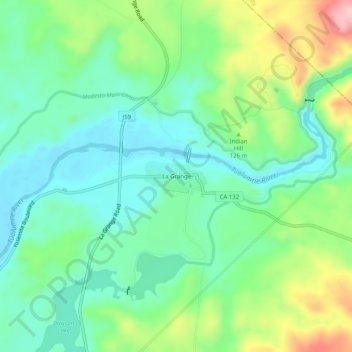
Name: Topografische Karte La Grange, Höhe, Relief.
Ort: La Grange, Stanislaus County, California, United States (37.64354 -120.48353 37.68354 -120.44353)
Durchschnittliche Höhe: 107 m
Minimale Höhe: 50 m
Maximale Höhe: 231 m
Spenden
Rüste dich für dein nächstes Abenteuer:
Als Amazon-Partner verdient diese Website an qualifizierten Käufen, ohne zusätzliche Kosten für Sie.
Andere topografische Karten
Klicken Sie auf eine Karte, um ihre Topografie, ihre Höhe und ihr Relief anzuzeigen.
Oakdale
United States > California > Stanislaus County
Historically the area has been used for orchards and other agricultural uses. Some of the common soil types found in Oakdale are Delhi sand, Oakdale sandy loam, Hanford sandy loam, and Tujunga loamy sand. Oakdale is generally on level ground at an elevation of approximately 190 feet (58 m) above mean sea…
Durchschnittliche Höhe: 66 m
Oakdale
United States > California > Stanislaus County
Historically the area has been used for orchards and other agricultural uses. Some of the common soil types found in Oakdale are Delhi sand, Oakdale sandy loam, Hanford sandy loam, and Tujunga loamy sand. Oakdale is generally on level ground at an elevation of approximately 190 feet (58 m) above mean sea…
Durchschnittliche Höhe: 52 m
Spenden
Rüste dich für dein nächstes Abenteuer:
Als Amazon-Partner verdient diese Website an qualifizierten Käufen, ohne zusätzliche Kosten für Sie.
Oakdale
United States > California > Stanislaus County
Historically the area has been used for orchards and other agricultural uses. Some of the common soil types found in Oakdale are Delhi sand, Oakdale sandy loam, Hanford sandy loam, and Tujunga loamy sand. Oakdale is generally on level ground at an elevation of approximately 190 feet (58 m) above mean sea…
Durchschnittliche Höhe: 57 m
Waterford
United States > California > Stanislaus County
The city was founded around the Tuolumne River. City population signs report Waterford's elevation is 51 feet (16 m) above sea level.
Durchschnittliche Höhe: 49 m
San Joaquin River National Wildlife Refuge
United States > California > Stanislaus County
Durchschnittliche Höhe: 14 m
Spenden
Rüste dich für dein nächstes Abenteuer:
Als Amazon-Partner verdient diese Website an qualifizierten Käufen, ohne zusätzliche Kosten für Sie.