
Topografische Karte Shrewsbury
Interaktive Karte
Klicken Sie auf die Karte, um die Höhe anzuzeigen.
Shrewsbury
The town centre is partially built on a hill whose elevation is, at its highest, 246 feet (75 m) above sea level. The longest river in the United Kingdom, the River Severn, flows through the town, forming a meander around its centre. The Rea Brook is a small river that has its confluence with the Severn at Shrewsbury, just upstream from the English Bridge, and much of the Rea Brook Valley within the town is a country park and local nature reserve, encompassing 36 hectares (89 acres). The town is subject to flooding from these rivers.
Über diese Karte
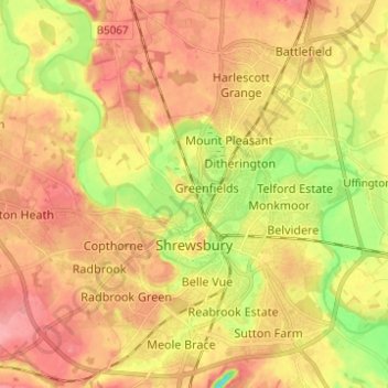
Name: Topografische Karte Shrewsbury, Höhe, Relief.
Ort: Shrewsbury, Shropshire, England, United Kingdom (52.68019 -2.81432 52.75498 -2.70122)
Durchschnittliche Höhe: 69 m
Minimale Höhe: 19 m
Maximale Höhe: 103 m
Andere topografische Karten
Klicken Sie auf eine Karte, um ihre Topografie, ihre Höhe und ihr Relief anzuzeigen.