
Spenden
Rüste dich für dein nächstes Abenteuer:
Als Amazon-Partner verdient diese Website an qualifizierten Käufen, ohne zusätzliche Kosten für Sie.
Topografische Karte Golden Gate Park
Klicken Sie auf die Karte, um die Höhe anzuzeigen.
Spenden
Rüste dich für dein nächstes Abenteuer:
Als Amazon-Partner verdient diese Website an qualifizierten Käufen, ohne zusätzliche Kosten für Sie.
Golden Gate Park
Conceived ostensibly for recreation, the underlying purpose of the park was housing development and the westward expansion of the city. Field engineer William Hammond Hall prepared a survey and topographic map of the park site in 1870 and became its commissioner in 1871. He was later named California's first state engineer and developed an integrated flood control system for the Sacramento Valley. The park drew its name from the nearby Golden Gate Strait.
Spenden
Rüste dich für dein nächstes Abenteuer:
Als Amazon-Partner verdient diese Website an qualifizierten Käufen, ohne zusätzliche Kosten für Sie.
Über diese Karte
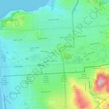
Name: Topografische Karte Golden Gate Park, Höhe, Relief.
Ort: Golden Gate Park, San Francisco, California, United States (37.76414 -122.51087 37.77465 -122.45318)
Durchschnittliche Höhe: 71 m
Minimale Höhe: -1 m
Maximale Höhe: 272 m
Spenden
Rüste dich für dein nächstes Abenteuer:
Als Amazon-Partner verdient diese Website an qualifizierten Käufen, ohne zusätzliche Kosten für Sie.
Andere topografische Karten
Klicken Sie auf eine Karte, um ihre Topografie, ihre Höhe und ihr Relief anzuzeigen.
San Francisco Bay Area
United States > California > San Francisco
The San Francisco Bay Area is characterized by a diverse and dynamic topography shaped by geological processes over millions of years. This region features a combination of coastal plains, steep hills, and rugged mountains, all influenced by the tectonic activity associated with the nearby San Andreas Fault…
Durchschnittliche Höhe: 113 m
Spenden
Rüste dich für dein nächstes Abenteuer:
Als Amazon-Partner verdient diese Website an qualifizierten Käufen, ohne zusätzliche Kosten für Sie.
San Francisco Bay Area
United States > California > San Francisco
The borders of the San Francisco Bay Area are not officially delineated, and the unique development patterns influenced by the region's topography, as well as unusual commute patterns caused by the presence of three central cities and employment centers located in various suburban locales, has led to…
Durchschnittliche Höhe: 113 m
Spenden
Rüste dich für dein nächstes Abenteuer:
Als Amazon-Partner verdient diese Website an qualifizierten Käufen, ohne zusätzliche Kosten für Sie.
Spenden
Rüste dich für dein nächstes Abenteuer:
Als Amazon-Partner verdient diese Website an qualifizierten Käufen, ohne zusätzliche Kosten für Sie.
Spenden
Rüste dich für dein nächstes Abenteuer:
Als Amazon-Partner verdient diese Website an qualifizierten Käufen, ohne zusätzliche Kosten für Sie.