
Topografische Karte Custines
Interaktive Karte
Klicken Sie auf die Karte, um die Höhe anzuzeigen.
Über diese Karte
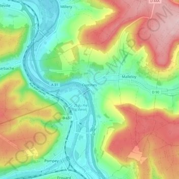
Name: Topografische Karte Custines, Höhe, Relief.
Durchschnittliche Höhe: 275 m
Minimale Höhe: 181 m
Maximale Höhe: 410 m
Andere topografische Karten
Klicken Sie auf eine Karte, um ihre Topografie, ihre Höhe und ihr Relief anzuzeigen.
city de boutet de monvel (ethanlecartographe
France > Grand Est > Meurthe-et-Moselle > Lunéville
city de boutet de monvel (ethanlecartographe, Lunéville, Meurthe-et-Moselle, Grand Est, Metropolitan France, 54300, France
Durchschnittliche Höhe: 240 m
Tomblaine
France > Grand Est > Meurthe-et-Moselle > Tomblaine
Tomblaine, Nancy, Meurthe-et-Moselle, Grand Est, Metropolitan France, 54510, France
Durchschnittliche Höhe: 206 m
Nancy
France > Grand Est > Meurthe-et-Moselle > Nancy
Nancy, Meurthe-et-Moselle, Grand Est, Metropolitan France, France
Durchschnittliche Höhe: 230 m