
Topografische Karte Kingman Lake
Interaktive Karte
Klicken Sie auf die Karte, um die Höhe anzuzeigen.
Über diese Karte
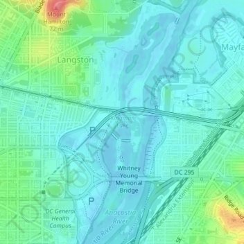
Name: Topografische Karte Kingman Lake, Höhe, Relief.
Durchschnittliche Höhe: 14 m
Minimale Höhe: -4 m
Maximale Höhe: 70 m
Andere topografische Karten
Klicken Sie auf eine Karte, um ihre Topografie, ihre Höhe und ihr Relief anzuzeigen.
National Mall
USA > District of Columbia > Washington
National Mall, Penn Quarter, Washington, District of Columbia, USA
Durchschnittliche Höhe: 14 m
Fort Totten Park
USA > District of Columbia > Washington
Fort Totten Park, Fort Totten, Washington, District of Columbia, USA
Durchschnittliche Höhe: 63 m
Mount Hamilton
USA > District of Columbia > Washington
Mount Hamilton, Washington, District of Columbia, DC 20002, USA
Durchschnittliche Höhe: 23 m