
Topografische Karte City of Binghamton
Interaktive Karte
Klicken Sie auf die Karte, um die Höhe anzuzeigen.
Über diese Karte
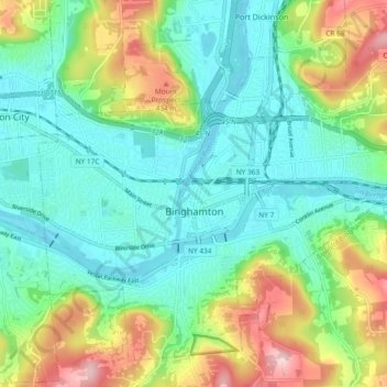
Name: Topografische Karte City of Binghamton, Höhe, Relief.
Durchschnittliche Höhe: 321 m
Minimale Höhe: 248 m
Maximale Höhe: 488 m
Binghamton, like all of the Southern Tier of New York, lies on the Allegheny Plateau; hence its hilly terrain. As such, elevations can vary in the city--Downtown, for example, is at an elevation of around 860 feet, while residential homes in the hills can go up to over 1,800 feet, such as on Ingram Hill. The highest peak in Binghamton is Table Rock Ridge, which is at 1,854 feet.
Andere topografische Karten
Klicken Sie auf eine Karte, um ihre Topografie, ihre Höhe und ihr Relief anzuzeigen.
Town of Colesville
United States > New York > Broome County
Town of Colesville, Broome County, New York, United States
Durchschnittliche Höhe: 413 m
Town of Conklin
United States > New York > Broome County
Town of Conklin, Town of Binghamton, Broome County, New York, United States
Durchschnittliche Höhe: 381 m
Town of Vestal
United States > New York > Broome County
Town of Vestal, Broome County, New York, United States
Durchschnittliche Höhe: 372 m