
Topografische Karte Eastsound
Interaktive Karte
Klicken Sie auf die Karte, um die Höhe anzuzeigen.
Über diese Karte
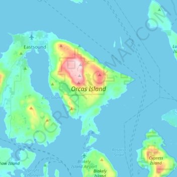
Name: Topografische Karte Eastsound, Höhe, Relief.
Durchschnittliche Höhe: 59 m
Minimale Höhe: -1 m
Maximale Höhe: 723 m
Mount Constitution (elevation 2,409 feet (734 meters) is the highest point in the San Juan islands. The mountain is part of Moran State Park, the largest public recreation area in the San Juan Islands, and the largest State Park in Washington. Moran State Park encompasses over 5,000 acres (2,000 hectares) of woodland and has several lakes, including Cascade Lake, Mountain Lake, Summit Lake, and Twin Lakes, and numerous waterfalls.
Andere topografische Karten
Klicken Sie auf eine Karte, um ihre Topografie, ihre Höhe und ihr Relief anzuzeigen.
San Juan Islands National Wildlife Refuge
United States > Washington > San Juan County
San Juan Islands National Wildlife Refuge, San Juan County, Washington, United States
Durchschnittliche Höhe: 24 m
O'Neal Island
United States > Washington > San Juan County
O'Neal Island, San Juan County, Washington, United States
Durchschnittliche Höhe: 18 m
Friday Harbor
United States > Washington > San Juan County
Friday Harbor, San Juan County, Washington, 98250, United States
Durchschnittliche Höhe: 28 m
Ben Nevis
United States > Washington > San Juan County
Ben Nevis, San Juan County, Washington, 98286, United States
Durchschnittliche Höhe: 49 m
Spencer Lake
United States > Washington > San Juan County > Thatcher
Spencer Lake, Thatcher, San Juan County, Washington, United States
Durchschnittliche Höhe: 150 m
Eastsound
United States > Washington > San Juan County
Eastsound, San Juan County, Washington, 98245, United States
Durchschnittliche Höhe: 74 m