
Topografische Karte Douglasville
Interaktive Karte
Klicken Sie auf die Karte, um die Höhe anzuzeigen.
Über diese Karte
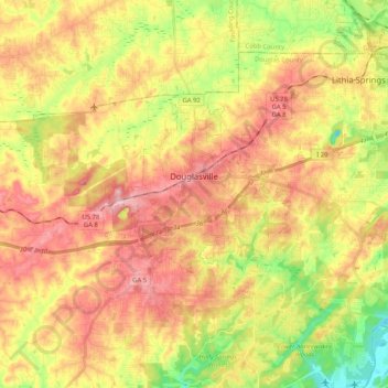
Name: Topografische Karte Douglasville, Höhe, Relief.
Ort: Douglasville, Douglas County, Georgia, United States (33.69597 -84.79482 33.79098 -84.58940)
Durchschnittliche Höhe: 310 m
Minimale Höhe: 218 m
Maximale Höhe: 389 m
Located along a natural rise in the topography, Douglasville was originally known as "Skint Chestnut." The name was derived from a large tree used by Native Americans as a landmark; it was stripped of its bark so as to be more conspicuous.
Andere topografische Karten
Klicken Sie auf eine Karte, um ihre Topografie, ihre Höhe und ihr Relief anzuzeigen.
Fairplay
United States > Georgia > Douglas County
Fairplay, Douglas County, Georgia, United States
Durchschnittliche Höhe: 330 m
Lithia Springs
United States > Georgia > Douglas County
Lithia Springs, Douglas County, Georgia, 30122, United States
Durchschnittliche Höhe: 295 m
Shelby Forest
United States > Georgia > Douglas County
Shelby Forest, Douglas County, Georgia, 30135, United States
Durchschnittliche Höhe: 309 m
Winston
United States > Georgia > Douglas County
Winston, Douglas County, Georgia, 30187, United States
Durchschnittliche Höhe: 340 m
Cheviot Hills
United States > Georgia > Douglas County
Cheviot Hills, Douglas County, Georgia, United States
Durchschnittliche Höhe: 325 m
McWhorter
United States > Georgia > Douglas County
McWhorter, Douglas County, Georgia, United States
Durchschnittliche Höhe: 308 m
Midway
United States > Georgia > Douglas County > Douglasville > Midway
Midway, Douglasville, Douglas County, Georgia, United States
Durchschnittliche Höhe: 328 m
Douglasville Lake Dam
United States > Georgia > Douglas County > Douglasville
Douglasville Lake Dam, Douglasville, Douglas County, Georgia, 30135, United States
Durchschnittliche Höhe: 328 m