
Topografische Karte Stone Mountain State Park
Interaktive Karte
Klicken Sie auf die Karte, um die Höhe anzuzeigen.
Über diese Karte
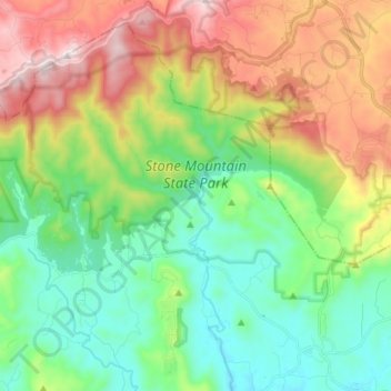
Name: Topografische Karte Stone Mountain State Park, Höhe, Relief.
Durchschnittliche Höhe: 641 m
Minimale Höhe: 351 m
Maximale Höhe: 1.170 m
The centerpiece of the park is Stone Mountain, a dome of exposed granite (specifically a quartz diorite to granodiorite) of Devonian age, which has intruded into the gneiss of the Precambrian Alligator Back Formation. It rises sharply over 600 feet (183 m) above the surrounding terrain. The mountain, which has an elevation of 2,305 feet (706 m) above sea level, is known for its barren sides and distinctive brown-gray color, and can be seen for miles. The mountain offers some of the best rock climbing in North Carolina, and the park's creeks and streams feature excellent brook trout fishing.
Andere topografische Karten
Klicken Sie auf eine Karte, um ihre Topografie, ihre Höhe und ihr Relief anzuzeigen.
Wilkesboro
United States > North Carolina > Wilkes County
Wilkesboro, Wilkes County, North Carolina, United States
Durchschnittliche Höhe: 352 m
Roaring River
United States > North Carolina > Wilkes County
Roaring River, Wilkes County, North Carolina, United States
Durchschnittliche Höhe: 362 m
North Wilkesboro
United States > North Carolina > Wilkes County
North Wilkesboro, Wilkes County, North Carolina, United States
Durchschnittliche Höhe: 345 m
Burke Mountain
United States > North Carolina > Wilkes County
Burke Mountain, Wilkes County, North Carolina, 28649, United States
Durchschnittliche Höhe: 603 m
Moravian Falls
United States > North Carolina > Wilkes County > Moravian Falls
Moravian Falls, Wilkes County, North Carolina, United States
Durchschnittliche Höhe: 361 m