
Topografische Karte Rapids
Interaktive Karte
Klicken Sie auf die Karte, um die Höhe anzuzeigen.
Über diese Karte
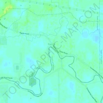
Name: Topografische Karte Rapids, Höhe, Relief.
Durchschnittliche Höhe: 179 m
Minimale Höhe: 175 m
Maximale Höhe: 187 m
Andere topografische Karten
Klicken Sie auf eine Karte, um ihre Topografie, ihre Höhe und ihr Relief anzuzeigen.
Town of Lewiston
United States > New York > Niagara County
Town of Lewiston, Niagara County, New York, United States
Durchschnittliche Höhe: 134 m
Black Creek Village
United States > New York > Niagara County > City of Niagara Falls
Black Creek Village, City of Niagara Falls, Niagara County, New York, 14304, United States
Durchschnittliche Höhe: 176 m
Village of Lewiston
United States > New York > Niagara County > Town of Lewiston
Village of Lewiston, Town of Lewiston, Town of Niagara, Niagara County, New York, United States
Durchschnittliche Höhe: 122 m
City of Niagara Falls
United States > New York > Niagara County
City of Niagara Falls, Niagara County, New York, United States
Durchschnittliche Höhe: 180 m
Niagara Escarpment
United States > New York > Niagara County > City of Lockport
Niagara Escarpment, City of Lockport, Town of Lockport, Niagara County, New York, 14094, United States
Durchschnittliche Höhe: 165 m
Shooktown
United States > New York > Niagara County > City of Lockport
Shooktown, City of Lockport, Town of Lockport, Niagara County, New York, 14094, United States
Durchschnittliche Höhe: 191 m
Lewiston Heights
United States > New York > Niagara County > Town of Lewiston > Village of Lewiston
Lewiston Heights, Village of Lewiston, Town of Lewiston, Town of Niagara, Niagara County, New York, 14092, United States
Durchschnittliche Höhe: 144 m
City of Lockport
United States > New York > Niagara County
City of Lockport, Niagara County, New York, 14094, United States
Durchschnittliche Höhe: 174 m