
Topografische Karte Clare Island
Interaktive Karte
Klicken Sie auf die Karte, um die Höhe anzuzeigen.
Über diese Karte
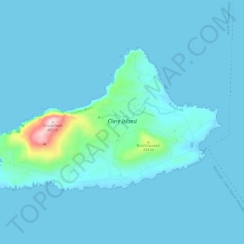
Name: Topografische Karte Clare Island, Höhe, Relief.
Durchschnittliche Höhe: 29 m
Minimale Höhe: 0 m
Maximale Höhe: 456 m
Andere topografische Karten
Klicken Sie auf eine Karte, um ihre Topografie, ihre Höhe und ihr Relief anzuzeigen.
Claremorris-Swinford Municipal District
Claremorris-Swinford Municipal District, County Mayo, Connacht, Ireland
Durchschnittliche Höhe: 69 m
Saleen
Saleen, Hollymount Electoral Division, Claremorris-Swinford Municipal District, County Mayo, Connacht, Ireland
Durchschnittliche Höhe: 34 m
Castlebar
Castlebar, Castlebar Municipal District, County Mayo, Connacht, Ireland
Durchschnittliche Höhe: 44 m
Craggy
Craggy, Clare Island ED, Westport-Belmullet Municipal District, County Mayo, Connacht, Ireland
Durchschnittliche Höhe: 41 m
Ballina Municipal District
Ballina Municipal District, County Mayo, Connacht, Ireland
Durchschnittliche Höhe: 74 m
Blowhole
Blowhole, Ballycastle ED, Ballina Municipal District, County Mayo, Connacht, Ireland
Durchschnittliche Höhe: 43 m
Castlebar Municipal District
Castlebar Municipal District, County Mayo, Connacht, Ireland
Durchschnittliche Höhe: 85 m
Achill Island
Achill Island, County Mayo, Connacht, F28 X018, Ireland
Durchschnittliche Höhe: 42 m
Westport
Ireland > County Mayo > Westport
Westport, Westport-Belmullet Municipal District, County Mayo, Connacht, F28 RD39, Ireland
Durchschnittliche Höhe: 40 m