Topografische Karte Bengkulu
Interaktive Karte
Klicken Sie auf die Karte, um die Höhe anzuzeigen.
Über diese Karte
![Topografische Karte Bengkulu, Höhe, Relief](/pub/maps/relation/34s/394vz4/thumbnail.jpg)
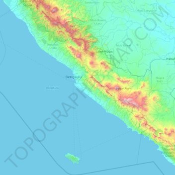
Name: Topografische Karte Bengkulu, Höhe, Relief.
Ort: Bengkulu, Sumatra, Indonesien (-5.71899 100.62049 -2.28865 103.78107)
Durchschnittliche Höhe: 181 m
Minimale Höhe: 0 m
Maximale Höhe: 3.051 m
Andere topografische Karten
Klicken Sie auf eine Karte, um ihre Topografie, ihre Höhe und ihr Relief anzuzeigen.
![Topografische Karte Ubud, Höhe, Relief](/pub/maps/node/ltmt/fp52zrr/icon.jpg)
Ubud
Indonesien > Bali > Gianyar
Ubud, Gianyar, Bali, Nusa Tenggara, 80571, Indonesien
Durchschnittliche Höhe: 215 m
![Topografische Karte Gili Air, Höhe, Relief](/pub/maps/way/dw14/6s9pkgt/icon.jpg)
Gili Air
Indonesien > West-Nusa Tenggara > Lombok Utara
Gili Air, Lombok Utara, West-Nusa Tenggara, Nusa Tenggara, 83300, Indonesien
Durchschnittliche Höhe: 1 m
![Topografische Karte Sonderregion Yogyakarta, Höhe, Relief](/pub/maps/relation/99zs/dpdn14/icon.jpg)
Sonderregion Yogyakarta
Sonderregion Yogyakarta, Jawa, Indonesien
Durchschnittliche Höhe: 141 m
![Topografische Karte Lolong Belanti, Höhe, Relief](/pub/maps/node/28nx/8l2hpp14/icon.jpg)
Lolong Belanti
Indonesien > Sumatra Barat > Padang
Lolong Belanti, Padang, Sumatra Barat, Sumatra, 25136, Indonesien
Durchschnittliche Höhe: 7 m
![Topografische Karte Ost-Nusa Tenggara, Höhe, Relief](/pub/maps/node/d2z4/3l54lsz4/icon.jpg)
Ost-Nusa Tenggara
Indonesien > Ost-Nusa Tenggara
Ost-Nusa Tenggara, Nusa Tenggara, Indonesien
Durchschnittliche Höhe: 38 m
![Topografische Karte Gambir, Höhe, Relief](/pub/maps/node/36mt/l3r93cmt/icon.jpg)
Gambir
Indonesien > Besondere Hauptstadtregion Jakarta
Gambir, Jakarta Pusat, Besondere Hauptstadtregion Jakarta, Jawa, 10160, Indonesien
Durchschnittliche Höhe: 14 m
![Topografische Karte Kabupaten Nabire, Höhe, Relief](/pub/maps/relation/9gtf/x44js8/icon.jpg)
Kabupaten Nabire
Indonesien > Papua Tengah > Kabupaten Nabire
Kabupaten Nabire, Papua Tengah, Indonesien
Durchschnittliche Höhe: 665 m
![Topografische Karte Hairapara, Höhe, Relief](/pub/maps/node/kzs/h8cs67gt/icon.jpg)
Hairapara
Indonesien > West-Papua > Hairapara
Hairapara, West-Papua, Indonesien
Durchschnittliche Höhe: 938 m
![Topografische Karte Irilingga, Höhe, Relief](/pub/maps/node/sz4/zpwr2p5k/icon.jpg)
Irilingga
Indonesien > Papua Pegunungan > Jayawijaya > Irilingga
Irilingga, Bpiri, Jayawijaya, Papua Pegunungan, Indonesien
Durchschnittliche Höhe: 2.101 m
![Topografische Karte Empanang, Höhe, Relief](/pub/maps/relation/rscz/clcw3l/icon.jpg)
Empanang
Indonesien > West-Kalimantan > Kapuas Hulu
Empanang, Kapuas Hulu, West-Kalimantan, Indonesien
Durchschnittliche Höhe: 90 m
![Topografische Karte Lewokluok, Höhe, Relief](/pub/maps/node/lp1h/p4n8jqdn/icon.jpg)
Lewokluok
Indonesien > Ost-Nusa Tenggara > Flores Timur > Lewokluok
Lewokluok, Flores Timur, Ost-Nusa Tenggara, Indonesien
Durchschnittliche Höhe: 730 m
![Topografische Karte Weawen, Höhe, Relief](/pub/maps/node/711h/6ndxbznh/icon.jpg)
Weawen
Indonesien > Papua > Yahukimo > Weawen
Weawen, Yahukimo, Papua, Indonesien
Durchschnittliche Höhe: 1.905 m
![Topografische Karte Putri Betung, Höhe, Relief](/pub/maps/relation/c73q/q1m7tf/icon.jpg)
Putri Betung
Indonesien > Aceh > Gayo Lues
Putri Betung, Gayo Lues, Aceh, Indonesien
Durchschnittliche Höhe: 1.537 m
![Topografische Karte Gemboyah, Höhe, Relief](/pub/maps/node/l4dn/h8zcmnmt/icon.jpg)
Gemboyah
Indonesien > Aceh > Aceh Tengah > Gemboyah
Gemboyah, Linge, Aceh Tengah, Aceh, Indonesien
Durchschnittliche Höhe: 2.273 m
![Topografische Karte Kota Bandung, Höhe, Relief](/pub/maps/relation/hmt/kgqxrr/icon.jpg)
Kota Bandung
Kota Bandung, West-Java, Jawa, Indonesien
Durchschnittliche Höhe: 824 m
![Topografische Karte Karawang, Höhe, Relief](/pub/maps/node/mn1h/4wfm6251/icon.jpg)
Karawang
Indonesien > West-Java > Karawang
Karawang, West-Java, 41312, Indonesien
Durchschnittliche Höhe: 25 m
![Topografische Karte Bitung, Höhe, Relief](/pub/maps/node/rstj/2k7q1mrr/icon.jpg)
Bitung
Indonesien > Nord-Sulawesi > Bitung
Bitung, Nord-Sulawesi, 95522, Indonesien
Durchschnittliche Höhe: 115 m
![Topografische Karte Jakarta Pusat, Höhe, Relief](/pub/maps/relation/kff3/xvr118/icon.jpg)
Jakarta Pusat
Indonesien > Besondere Hauptstadtregion Jakarta
Jakarta Pusat, Besondere Hauptstadtregion Jakarta, Indonesien
Durchschnittliche Höhe: 10 m
![Topografische Karte Kepulauan Seribu Utara, Höhe, Relief](/pub/maps/node/rt5k/6jfhcdz4/icon.jpg)
Kepulauan Seribu Utara
Indonesien > Besondere Hauptstadtregion Jakarta
Kepulauan Seribu Utara, Besondere Hauptstadtregion Jakarta, Indonesien
Durchschnittliche Höhe: 0 m
![Topografische Karte West-Nusa Tenggara, Höhe, Relief](/pub/maps/relation/k14s/l9klf3/icon.jpg)
West-Nusa Tenggara
West-Nusa Tenggara, Nusa Tenggara, Indonesien
Durchschnittliche Höhe: 45 m
![Topografische Karte Gunung Tanggamus, Höhe, Relief](/pub/maps/node/mfz4/15pvxtm2/icon.jpg)
Gunung Tanggamus
Gunung Tanggamus, Lampung, Indonesien
Durchschnittliche Höhe: 862 m
![Topografische Karte Koreiha, Höhe, Relief](/pub/maps/node/ml51/1nrtvkrr/icon.jpg)
Koreiha
Indonesien > Südost-Sulawesi > Koreiha
Koreiha, Südost-Sulawesi, Indonesien
Durchschnittliche Höhe: 881 m