
Topografische Karte Maui
Interaktive Karte
Klicken Sie auf die Karte, um die Höhe anzuzeigen.
Über diese Karte
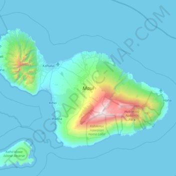
Name: Topografische Karte Maui, Höhe, Relief.
Ort: Maui, Maui County, Hawaii, United States (20.57443 -156.69726 21.03156 -155.97909)
Durchschnittliche Höhe: 232 m
Minimale Höhe: -4 m
Maximale Höhe: 3.044 m
Maui's diverse landscapes are the result of a unique combination of geology, topography, and climate. Each volcanic cone in the chain of the Hawaiian Islands is built of dark, iron-rich/quartz-poor rocks, which poured out of thousands of vents as highly fluid lava throughout millions of years. Several of the volcanoes were close enough to each other that lava flows on their flanks overlapped one another, merging into a single island. Maui is such a "volcanic doublet," formed from two shield volcanoes that overlapped one another to form an isthmus between them.
Andere topografische Karten
Klicken Sie auf eine Karte, um ihre Topografie, ihre Höhe und ihr Relief anzuzeigen.
Makawao
United States > Hawaii > Maui County
Makawao, Maui County, Hawaii, 96768, United States
Durchschnittliche Höhe: 524 m
Kihei
United States > Hawaii > Maui County > Kihei
Kihei, Maui County, Hawaii, United States
Durchschnittliche Höhe: 74 m
Haleakalā
United States > Hawaii > Maui County
Haleakalā, Maui County, Hawaii, United States
Durchschnittliche Höhe: 2.085 m
Lānaʻi
United States > Hawaii > Maui County
Lānaʻi, Maui County, Hawaii, 96763, United States
Durchschnittliche Höhe: 162 m
Lahaina
United States > Hawaii > Maui County > Lahaina
Lahaina, Maui County, Hawaii, United States
Durchschnittliche Höhe: 101 m