
Topografische Karte Dembéni
Interaktive Karte
Klicken Sie auf die Karte, um die Höhe anzuzeigen.
Über diese Karte
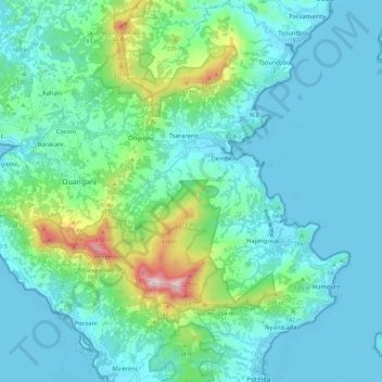
Name: Topografische Karte Dembéni, Höhe, Relief.
Ort: Dembéni, Mayotte, 97660, France (-12.88658 45.13879 -12.81953 45.25473)
Durchschnittliche Höhe: 111 m
Minimale Höhe: 0 m
Maximale Höhe: 619 m
Andere topografische Karten
Klicken Sie auf eine Karte, um ihre Topografie, ihre Höhe und ihr Relief anzuzeigen.
Bambo-Ouest
Bambo-Ouest, Bouéni, Mayotte, 97620, France
Durchschnittliche Höhe: 30 m
Dzoumogné
France > Mayotte > Bandraboua
Dzoumogné, Bandraboua, Mayotte, 97650, France
Durchschnittliche Höhe: 56 m
Tsoundzou 1
Tsoundzou 1, Mamoudzou, Mayotte, 97605, France
Durchschnittliche Höhe: 52 m
Chembenyoumba
France > Mayotte > M'Tsangamouji
Chembenyoumba, M'Tsangamouji, Mayotte, 97650, France
Durchschnittliche Höhe: 37 m
Petite-Terre
Petite-Terre, Dzaoudzi, Mayotte, 97610, France
Durchschnittliche Höhe: 10 m
Plage d'Iloni
Plage d'Iloni, Dembéni, Mayotte, 97660, France
Durchschnittliche Höhe: 33 m
Lac Dziani
Lac Dziani, Dzaoudzi, Mayotte, France
Durchschnittliche Höhe: 18 m
Chissioua Bandrélé
Chissioua Bandrélé, Bandrélé, Mayotte, 97620, France
Durchschnittliche Höhe: 1 m
Parc de la Pointe Mahabou
Parc de la Pointe Mahabou, Doujani, Mamoudzou, Mayotte, 97600, France
Durchschnittliche Höhe: 6 m
Chissioua Mtsamboro
Chissioua Mtsamboro, Mtsamboro, Mayotte, 97630, France
Durchschnittliche Höhe: 23 m
Îlot Mbouzi
Îlot Mbouzi, Mamoudzou, Mayotte, 97600, France
Durchschnittliche Höhe: 5 m