
Topografische Karte Fayetteville
Interaktive Karte
Klicken Sie auf die Karte, um die Höhe anzuzeigen.
Über diese Karte
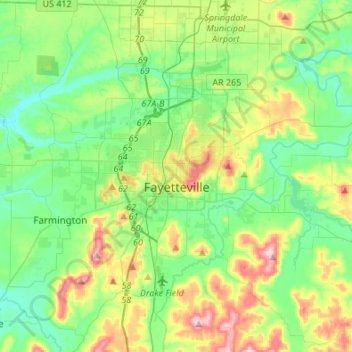
Name: Topografische Karte Fayetteville, Höhe, Relief.
Ort: Fayetteville, Washington County, Arkansas, United States (35.98936 -94.29778 36.14893 -94.02671)
Durchschnittliche Höhe: 401 m
Minimale Höhe: 325 m
Maximale Höhe: 581 m
...yet I venture the assertion that nowhere in said country—or for that matter, in any part of the state—could be found a lovelier elevation, or a lovelier grove of graceful oaks, or a more commanding view, or, in fine, a spot better suited and adapted for the purposes designated than the one chosen for said University [of Arkansas] site and farm.
Andere topografische Karten
Klicken Sie auf eine Karte, um ihre Topografie, ihre Höhe und ihr Relief anzuzeigen.
Prairie Grove
United States > Arkansas > Washington County
Prairie Grove, Washington County, Arkansas, 72753, United States
Durchschnittliche Höhe: 356 m
Springdale
United States > Arkansas > Washington County > Springdale
Springdale, Washington County, Arkansas, 72764, United States
Durchschnittliche Höhe: 388 m
Springdale
United States > Arkansas > Washington County
Springdale, Washington County, Arkansas, United States
Durchschnittliche Höhe: 398 m